Route Editor

| Guide | ♦ | 1 Triplog | 0 Topics |
details | drive | permit | forecast | 🔥 route |
stats |
photos | triplog | topics | location |
| 45 | 1 | 0 |
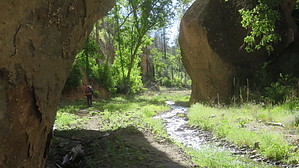
No Frijoles on trail so eat before for the hike by HikingBuddy The Frijole Canyon and Rim Trail is in the Bandelier National Monument (Bandelier), New Mexico. Bandelier is about 8 “bird miles” south of Los Alamos and has 33,677-acres (50 square miles) of land, 70% of which is part of the National Wilderness Preservation System. Note Pets, campfires, bicycles, and the use of weapons are not allowed in the monument’s Wilderness. Backpacking stoves must use fuel that doesn’t create ash.
Bandelier was home to the Ancestral Pueblo people who lived there from approximately 1150 CE to 1550 CE. Adolph Bandelier (1840 - 1914) is credited with doing the archeological research and documentation of the Puebloan ruins that led to its designation as a national monument by President Woodrow Wilson in 1916. Most of the preserved and accessible Puebloan ruins are in the Frijole Canyon near the visitor center however there are many other ruins in the Bandelier backcountry that are not fully excavated. There are 70 miles of trails in the Bandelier monument backcountry but many of the trails are in poor condition, difficult to find or completely washed away by floods that followed the Las Conchas Fire in 2011. Backcountry permits (no fee) are required for hikers/backpackers that intend to hike beyond the trails near visitor center. The permit can be obtained at the visitor center the first day of your hike but it’s a long ride from AZ to NM so call ahead to be sure. Day visitors must use the shuttle from White Rock or Los Alamos to get to the visitor center but backcountry hikers can drive all the way in and use special parking designated for backcountry hikers. The beautiful backcountry has colorful canyons with small/intermittent streams, lush vegetation, wildlife and sparsely wooded mesas characteristic of other high-elevation southwest desert landscapes. The elevations range from 5,500 ft at the canyon floors to the 7,500 ft mesas to nearly 8,200 ft at Boundary Peak. Hike The Frijole Canyon and Rim Trail is a super hike. The visitor center is about 6,000 ft elevation and the top of the Rim (mesa) nearly 7,500 ft. We started on a 4-day, 3-nite backpacking outing but cut it short by a day due to weather. The park rangers at the visitor center discouraged us from hiking through Frijole canyon because of all the debris on the trails from floods that followed the devastating fires a few years ago. We started our hike thinking we’d hike along the canyon Rim rather than in the canyon and then connect to Alamo and Capulin Canyons. However, the trail signs near the visitor center, although abundant, were a bit confusing and we liked the shady canyon so much we decided to keep on “truckin”. As it turned out we hiked the Frijole Canyon and Rim Trail loop that included a short side trip down into Alamo canyon to replenish our supply of water. The first mile or so of the trail parallels, and sometimes intersects, with the walkway that the day visitors use to access the Puebloan ruins. We ran into a little traffic and some flood debris along the trail at a few points but overall it was an easy trek for the first 2 to 3 miles. At about 3 miles into the hike we met up with the “backcountry ranger” and a youth corps crew restoring the trails. He said that the trail was rough going in places but the visitor center folks shouldn’t have discouraged us from hiking or backpacking in Frijole Canyon, or anywhere else in the Wilderness backcountry. Indeed, much of the trail along the creek has been washed away and/or blocked by large mounds of debris (fallen trees/branches). It was tough climbing over the debris with our backpacks but it wasn’t difficult to navigate along a canyon stream and the trails above the stream were still in pretty good shape. Frijole Canyon is a gem, as beautiful as any of the lush canyons in the southwest (e.g., Aravaipa, West Fork Oak Creek, etc... ) and flush with ruins. You’ll cross the creek several times and probably get your boots a little wet but not soaked like you would in Aravaipa. I created a route before the hike using Garmin BaseCamp and put it on my Garmin Etrex 20. My route had waypoints shown on the National Geographic topo map and on the New Mexico topo that I downloaded but neither matched the actual trails very well. Nevertheless, the navigating in the canyon was easy cuz you just need to follow the creek. We started on our trek in the afternoon so we had to find a campsite just 5 miles into the canyon. We found a site high enough off the canyon floor to protect ourselves from possible flood waters. The following morning we purified water from the stream and headed towards the mesa to pick up the Rim Trail. The climb was pretty steady but a little tough with nearly 40 lb backpacks (need to pack a whole lot lighter). Once up on the Rim it started to rain a bit, winds were crazy and there were thunderheads nearby so we decided make a side trip to Alamo Canyon and purify some more water for the day ahead. The second night we camped on the mesa where the heavy winds continued all night long. The hike along the Rim trail was void of debris and the trail easy to follow. The views of the canyon below and surrounding terrain was very special. Note Check out at the visitor center when you return - it's required!
Check out the Official Route and Triplog. Leave No Trace and +Add a Triplog after your hike to support this local community. | |||||||||||||||||||||||||||||||||||||||||||||||||||||||||||||||||||||||||||||||||||||||||||||||||||||||||||||||||