Route Editor

| Guide | 0 Triplogs | 0 Topics |
details | drive | permit | forecast | route |
stats |
photos | triplogs | topics | location |
| 7 | 0 | 0 |
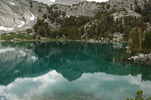
Truly a Gem by slegal The total round trip trail distance is about 0.60 miles. There is not a significant elevation gain along the trail, only about 70 feet. Please note that the trail difficulty is based on the fact that you have to hike up the Little Lakes Valley Trail to get to this trail, not because this trail is difficult by itself.
Upper Gem Lake should be around much longer. To get the best views of Upper Gem Lake, you will need to scramble up the rocks to the right of the trail. The water in Upper Gem Lake has an interesting color which is due to a high mineral content. The water is very clear as well allowing you to see the bottom of the lake with good detail. The lake is truly a gem! After the long hike to get to Upper Gem Lake, find a spot to have lunch or a snack. It is mostly downhill to get back to the Mosquito Flat Trailhead, but it's still a long trek. So enjoy the view, rest and recharge in this ideal spot. Check out the Official Route. Leave No Trace and +Add a Triplog after your hike to support this local community. | |||||||||||||||||||||||||||||||||||||||||||||||||||||||||||||||||||||||||||||||||||||||||||||