 Route Editor

| Guide | ♦ | 4 Triplogs | 0 Topics |
details | drive | no permit | forecast | 🔥 route |
stats |
photos | triplogs | topics | location |
| 41 | 4 | 0 |
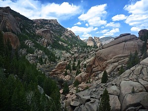
A gaggle of people (but no geese)! by chumley 2002 Hayman Fire: Driving to the Goose Creek trailhead is a sobering reminder of the consequences of carelessness with fire in the wilderness. The Hayman Fire burned 138,000 acres over a 6-week period in June and July of 2002. For the Arizona folks visiting this site, you may have never heard of the Hayman Fire because it burned at the same time that Arizona was fighting it's largest fire to date, the Rodeo-Chediski fire. The Hayman Fire was started by a US Forest Service employee who some speculate may have been motivated to start the fire so she could stay at home to fight a fire rather than having to travel out of state (Arizona). She was convicted in federal and state court of arson and is serving 18 years in prison. The scars of the fire cover the first few hundred yards of the hike, but the forest is otherwise intact and healthy for the entire route. Hike: The hike begins at the trailhead and heads down an easy slope through the burn area. At the bottom of the hill, the trail crosses a creek and turns right at a trail junction where the Hankins Pass Trail goes left. At the half-mile mark, the trail leaves the fire-scar area and enters the shade along Goose Creek, turning to the west and traveling along the creek for the next mile before leaving the creek and climbing steadily upward away from the creek. The next 2.5 miles is predominantly a slow climb, with some short descents through shaded pine forest. Except for some drainages that may be trickling lightly, there is no more water to be seen or heard. At the 4.1 mile mark, you will reach a signed trail for "Historic Buildings". It is highly recommended you make the 200-yard trek down to the cabins and read up on their history. If you have time, proceed 1/2 mile further to the old shaft house, where you will find the ruins of the attempted damming of Lost Creek as it ran underground. The area near the shaft house is stunningly beautiful, and carved with huge granite boulders and formations, and is worthy of some exploration. Back on the Goose Creek Trail, the trail climbs gently over the next .75 miles, before slowly dropping into Watkins Gulch at 1.25 miles from the buildings. From Watkins Gulch, the trail climbs a solid 1250 feet over the next 1.5 miles to the high point of the trail at 10,144 feet. About halfway up the climb (in both distance and elevation) you pass the junction with the McCurdy Park Trail which heads west. From the highpoint, the trail descends slowly for 2 miles, dropping 600 feet before reaching the cool waters of Wigwam Creek, the open meadow of Wigwam Park, and the junction with the Wigwam Trail. Camping: The lower portion of Goose Creek is very popular for overnight camping, and many sites exist. Users should not camp within 100 feet of either the creek or the trail, but existing sites clearly violate this requirement. There are sites near most trail junctions, and near the cabins and shaft house. Please limit impact whenever possible. You very likely will not find solitude along the lower 5-miles of this trail, especially on weekends. If you hope to camp alone, you will have to go farther. Check out the Official Route and Triplogs. Leave No Trace and +Add a Triplog after your hike to support this local community. One-Way Notice This hike is listed as One-Way. When hiking several trails on a single "hike", log it with a generic name that describes the hike. Then link the trails traveled, check out the example. | |||||||||||||||||||||||||||||||||||||||||||||||||||||||||||||||||||||||||||||||||||||||||||||||||||


