Route Editor

| Guide | ♦ | 13 Triplogs | 0 Topics |
details | drive | no permit | forecast | route |
stats |
photos | triplogs | topics | location |
| 64 | 13 | 0 |
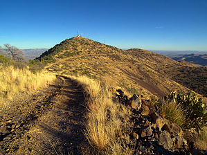
Glassford Hill's southern cousin by PrestonSands   Standing high above the lesser volcanic peaks of southeastern Arizona's Black Hills is Guthrie Peak, a long ridge of high desert grassland with outstanding views in every direction. Guthrie is an easy peak bag that can be combined with a drive down the B.L.M.'s scenic Black Hills Back Country Byway. This uniquely southern Arizona hike follows a primitive four wheel drive road along the northwest ridge of the mountain to the 6571 foot summit of Guthrie Peak. Standing high above the lesser volcanic peaks of southeastern Arizona's Black Hills is Guthrie Peak, a long ridge of high desert grassland with outstanding views in every direction. Guthrie is an easy peak bag that can be combined with a drive down the B.L.M.'s scenic Black Hills Back Country Byway. This uniquely southern Arizona hike follows a primitive four wheel drive road along the northwest ridge of the mountain to the 6571 foot summit of Guthrie Peak.The hike begins at a parking area next to a radio tower, at the junction of the Black Hills Back Country Byway and the Guthrie Peak Road. Start hiking up the Guthrie Peak Road, which gradually begins to climb the grass covered slopes of an ancient volcano. As the road climbs higher up the pinyon and juniper dotted mountainside, it gets steeper and rockier, while the views steadily improve. Far below, the Gila River and the Byway weave their way through the desert hills in the distance.
The service road soon arrives at the top of Guthrie Peak amid dozens of electronic and communication towers. There are endless views in all directions here. The north face of the peak is free of towers and yields spectacular views of the Clifton and White Mountain areas to the north. To the east, the Gila River flows some three thousand feet below, while the giant Mogollon Mountains of western New Mexico rise in the distance. On the return trip, there is the option for a through hike by following the service road down the south side of the peak. It is the far right, gated road at the three way fork. The service road descends for several miles to a mountain pass, where it meets highway 191 at milepost 147, about 26.3 miles east of the highway 191 and highway 70 junction in Safford. Otherwise, just head back the way you came, for a round trip total of 6 miles. Gate Policy: If a gate is closed upon arrival, leave it closed after you go through. If it is open, leave it open. Leaving a closed gate open may put cattle in danger. Closing an open gate may cut them off from water. Please be respectful, leave gates as found. The exception is signage on the gate directing you otherwise. Check out the Official Route and Triplogs. Leave No Trace and +Add a Triplog after your hike to support this local community. | |||||||||||||||||||||||||||||||||||||||||||||||||||||||||||||||||||||||||||||||||||||