Route Editor

| Guide | ♦ | 5 Triplogs | 0 Topics |
details | drive | permit | forecast | route |
stats |
photos | triplogs | topics | location |
| 86 | 5 | 0 |
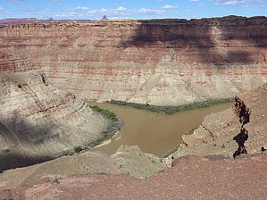
See you at the 'Y' by CannondaleKid  This hike is all about the destination, ending 1,100 feet above the confluence where the Green River flows into the Colorado River. At the confluence, at least when we were there, you can see the Colorado is the muddy brown river and the Green is, well, somewhat green. Warning This time of the year (mid October) we had beautiful weather, 40's to lower 60's so we didn't need much fluids. But with very little shade this could be one HOT hike in warmer months, so plan accordingly. Although some of the short climbs are steep, as one with an advanced fear of exposure/heights I had no issues at all on this hike. The one ladder was very easy.
The Confluence Overlook Trail begins at Big Spring Canyon Overlook TH/parking lot at the end of the paved Scenic Drive, 6.2 miles from the Canyonlands Visitor Center. Leaving the parking lot you head toward the sign marking the start of the trail, then right behind the sign, the trail drops quickly. It will wind 135' down into Big Spring Canyon, cross a few hundred feet of sandy bottom then climbs up on the other side. A word of advice... follow the well-placed cairns, DO NOT follow footsteps in the sand! Do this for the whole hike and you won't get lost. Climbing up the other side of Big Spring Canyon just follow the cairns leading straight up the canyon wall to a small ladder that leads you up to the canyon rim. At the top you will continue through a small passageway in the rocks. Soon after you will traverse a high open mesa for almost a mile. This part offers wide ranging views across desert grasslands and long depressions in the terrain called grabens. Next the trail descends into lower Elephant Canyon, passing through a dry wash before rising out of the canyon and again drops down into the grassy Twin Valleys. Next you will cross a Jeep road, scale an outcrop then drop into Cyclone Canyon. Soon you will cross Cyclone Canyon Trail at which point you want to bear right until connecting with the Jeep road again. Follow this road the rest of the way to the Confluence Overlook TH where there is a parking lot for 4x4's and an outdoor toilet. From there a Confluence Overlook sign directs you west for half a mile to Confluence Overlook. Be sure to take time to enjoy the views and the solitude... ok, we only had the solitude for 20 minutes before more people arrived. The return trip should be a breeze as you won't waste time looking for the route to follow. BTW, the rough 4x4 drive and short walk version of this hike is the Confluence Overlook. Water Sources Nothing to rely on. Camping Only with back-country permits.
Check out the Official Route and Triplogs. Leave No Trace and +Add a Triplog after your hike to support this local community. | |||||||||||||||||||||||||||||||||||||||||||||||||||||||||||||||||||||||||||||||||||||