 Route Editor

| Guide | ♦ | 3 Triplogs | 0 Topics |
details | drive | no permit | forecast | route |
stats |
photos | triplogs | topics | location |
| 0 | 3 | 0 |
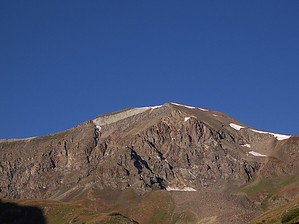
A dandy way to Handies by DixieFlyer This trail is most often used to ascend Handies Peak from the East Slopes. Prologue The Grizzly Gulch Trail is located in the astonishingly beautiful San Juan Mountains in southwest Colorado, near Lake City(pop. 408), which is the county seat of Hinsdale County. Hinsdale County has been called the most remote area in the continental U.S. Around 95% of Hinsdale County is federal land, and the U.S. Geological Survey says that the county has more wild and roadless land per capita than anywhere else in the continental U.S.
Grizzly Gulch is in an area of Colorado that began to be settled in the 1870's in conjunction with mines that produced gold, silver, copper, and lead. By 1900 the Tabasco Meat Sauce Company, which was the financier for a silver mine in the area, had built a 100 ton mill to process ore from the local mines. At one time Handies Peak was marked "Tabasco" on maps, after the aforementioned Tabasco Company. The origin of the name Handies is not known with certainty, but it is said to be named after a local pioneer who went by the name "Handie". Hike The Grizzly Gulch Trail provides an alternative route to the summit of Handies Peak(14,048') that is longer and has more elevation gain than the standard route up the southwest slopes via the American Basin Trail. The route via the Grizzly Gulch Trail is the more scenic of the two approaches to Handies; additionally, a 2WD vehicle with decent clearance can generally access the Grizzly Gulch TH, whereas a 4WD vehicle is needed to get to the American Basin TH. The Grizzly Gulch Trail is well marked and easy to follow. It is mostly a class 1 hike, but as you near the summit most people would consider the trail to be class 2. In any event, most hikers would not have any difficulty with the trail. The trail maintains a steady uphill grade for almost its entire length. The first 2 miles of the trail are through spruce, fir, and aspen forests. At around 11,800' of elevation you'll be above the treeline and the remainder of the hike will be through beautiful meadows that have cool views of Handies Peak. Not far to the north of the trail is Whitecross Mountain(13,542') -- an adventurous hiker might wish to make an off-trail ascent of this 13er. The trail steepens as you make your way to a ridgeline north of Handies -- at one point you'll gain 1,200' of elevation in less than 0.9 miles. Once you make the summit of Handies, enjoy the awesome views which make the hike very worthwhile! The Grizzly Gulch TH is across the road from the Silver Creek Trail, which is used to hike two other 14ers: Redcloud and Sunshine Peaks. Water Sources Water from the Lake Fork of the Gunnison River is available near the trailhead and along the lower parts of the trail. Camping Dispersed camping is available at the trailhead. Find a good spot and pitch your tent! Fees There are no fees for parking, hiking, or camping. Warning Thunderstorms are not uncommon during the summertime, so it is advisable to check weather forecasts before hiking this trail. Storms typically occur after 11:00 AM or so, so it is best to begin hiking early. Check out the Official Route and Triplogs. Leave No Trace and +Add a Triplog after your hike to support this local community. One-Way Notice This hike is listed as One-Way. When hiking several trails on a single "hike", log it with a generic name that describes the hike. Then link the trails traveled, check out the example. | |||||||||||||||||||||||||||||||||||||||||||||||||||||||||||||||||||||||||||||||||||||


