username
X
password
register
for free!
help
 This is likely a great time to hike this trail!  Check out "Preferred" months below, keep in mind this is an estimate.
  

Sipapu Bridge, UT

Guide 14 Triplogs  1 Topic
  4.1 of 5  
Fav
Wish
2
details
drive
permit
forecast
route  
stats
photos
triplogs
topic
location
132 14 1
HAZ reminds you to respect the ruins. Please read the Archaeological Resources Protection Act of 1979 & Ruins Etiquette
Statistics
tap row or icons for details
Difficulty 3 of 5
Route Finding 1 of 5
Distance Round Trip 1.2 miles
Trailhead Elevation 1,894 feet
Elevation Gain -400 feet
Avg Time Round Trip 1 hour
Kokopelli Seeds 3.2
 Interest Ruins & Seasonal Creek
 Backpack No
unreported if dogs are allowed
editedit > ops > dogs to adjust
feature photo
Photos Viewed All MineFollowing
4  2022-05-04 Yoder
30  2021-09-04
Sipapu-Owachomo Loop Trail
chumley
21  2021-05-15 sneakySASQUATCH
23  2017-10-05
Natural Bridges NM
AZWanderingBear
7  2016-04-18
Natural Bridges National Monument
trekkin_gecko
4  2014-12-28 Lucyan
13  2011-05-17 Kel1969
16  2011-04-01
Sipapu-Owachomo Loop Trail
GrottoGirl
Page 1,  2
Author
author avatar Guides 171
Routes 253
Photos 6,100
Trips 1,135 map ( 2,556 miles )
Age 44 Male Gender
Location Pocatello, ID
Associated Areas
list map done
Southeast Region
Historical Weather
Trailhead Forecast
Radar Map
Expand Map
Preferred Jul, Aug, Jun, Sep
Seasons   Early Autumn to Late Spring
Sun  5:53am - 6:43pm
Official Route
 
1 Alternative


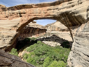
2nd largest natural bridge in America!
by PaleoRob

 Likely In-Season!
Natural Bridges National Monument is a relatively small park, with no backpacking opportunities and only a few maintained trails. Its natural, historic, and prehistoric attractions are almost out of scale, considering the monument's small size! The park contains hundreds of prehistoric Anasazi ruins, dozens of historic sites, and three of the largest natural bridges in the United States. Natural bridges are formed differently than natural arches. While natural arches, such as are common at the nearby Arches National Park, look similar, natural arches are not formed by water flowing under them. As the name implies, Bridges span a creek or other body of flowing or previously flowing water.


Sipapu Bridge is the largest of the three bridges in Natural Bridges National Monument and the second-largest natural bridge, after Rainbow Bridge, in the United States. The trail to Sipapu is steep and can be very icy during the winter.
remove free decal offer
Starting from the paved parking lot, the trail descends in easy switchbacks across a slickrock slope until reaching a slickrock bench. The trail then heads westerly along this bench until you reach the top of one of two staircases built into the cliff face. This allows access to the lower sections of the canyon, otherwise inaccessible due to a sheer cliff of about 200 feet. The trail then continues by the cliff face, shaded year-round with large pine trees, along a narrow ledge.

After a short descent, the ledge flattens out again, and the trail branches by a beat-up Anasazi granary and a trail register that is no longer used. Continuing along the ledge leads to a point with a nice view of Sipapu Bridge below in the canyon. Following the trail heading down from the trail register will take you to Sipapu Bridge itself.

Below the register, the trail goes into a series of steep switchbacks to cross a talus slope. They can be narrow and rocky at times, so watch your footing. When the switchbacks end, you are on a slickrock slope again, with a nice view of Sipapu Bridge looming across the canyon in front of you. The slickrock crossing is the trickiest part of the hike, as it is often steep and can be snowy/icy/slippery during the winter. A seasonal spring occasionally flows during the slickrock crossing, and algae can make this section treacherous even during warmer months when there is no ice. This is an easy place to twist an ankle.

The Park Service has installed metal railings for portions of this crossing, and you would be well advised to use them. There are also three log ladders in place to help with steep sections of slickrock and overhangs. They can be slightly unnerving, but rest assured that they are sturdy enough for most people.

The final ladder sets you down in a grove of Gambel Oak directly below Sipapu Bridge. Looking up through the leaves is a neat sight. The trail heads towards the center of the bridge, where a sandbar clear of trees allows for a clearer view of the size of the span. Sit back, have lunch, enjoy Armstrong Creek running across the boulders and sand. Done relaxing? Then hit the trail either back to the trailhead or downcanyon on a hike to either Horsecollar Ruin or one of the other natural bridges.

While there is a small spring on the slopes above Sipapu and Armstrong Creek runs frequently, it is recommended to fill all your bottles of water at the Visitor's Center.

2007-12-23 PaleoRob


    Check out the Official Route and Triplogs.
    Leave No Trace and +Add a Triplog after your hike to support this local community.
    WARNING! Hiking and outdoor related sports can be dangerous. Be responsible and prepare for the trip. Study the area you are entering and plan accordingly. Dress for the current and unexpected weather changes. Take plenty of water. Never go alone. Make an itinerary with your plan(s), route(s), destination(s) and expected return time. Give your itinerary to trusted family and/or friends.

     Permit $$
    NPS

    Natural Bridges National Monument
    $6 per car (Good for 7 days) Entrance Fee


     Directions
    or
     Road
    Paved - Car Okay

    To hike
    From Blanding, Utah, take Utah Route 95 west, following the signs to Natural Bridges National Monument. Turn left on Utah Route 275 (also signed for Natural Bridges). Enter the Monument, and stop at the visitor's center to pay the fee. Continue down the road to the T-junction and turn right on the one-way Bridge View loop road. Continue past the Sipapu Bridge overlook parking area, and turn off just down the road, on the right-hand side, at the Sipapu Bridge trailhead. It is a large paved parking lot with signs at the trailhead, and parking on either side; impossible to miss. Park there, and begin your hike.
     90+° 8am - 6pm kills
    helpcorrectionissue

    end of page marker