 Route Editor

| Guide | ♦ | 164 Triplogs | 6 Topics |
details | drive | permit | forecast | route |
stats |
photos | triplogs | topics | location |
| 1.8k | 164 | 6 |
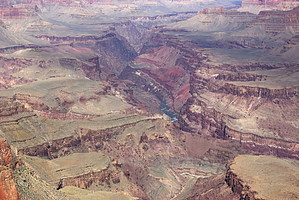
Back in Time by HAZ_Hikebot   History HistoryThe lower reaches of the Grand Canyon below Desert View are dominated by a series of tilted layers of stone known as the Grand Canyon Supergroup. The Supergroup is a complex collection of ancient sedimentary and igneous rocks ranging in age from 800 million to 1.2 billion years, the oldest sedimentary deposits in the canyon. The colorful rocks are soft and easily eroded, so the canyon floor is unusually expansive, offering unimpeded views of some of the steepest walls to be found below the rim. In addition to being geologically noteworthy, the Tanner Trail is also historically significant. Native people used this natural rim-to-river route for several thousand years, and the trail as we know it today has been in constant use since 1890 (when Franklin French and Seth Tanner improved it). The Tanner Trail allowed early miners access to their claims and was used as the southern component of the disreputable Horsethief Route. Wilderness seekers are only the latest humans to discover the charms of the area.
Hike What remains of a once-popular pioneer-era trail goes down the gully immediately east of Lipan Point. The upper section of the Tanner Trail is narrow, badly eroded, and can be difficult to follow, especially after a winter storm. The trail stays on the slopes east of the bottom of the gully through the Toroweap and switches to the west side at the top of the Coconino. Rock slides in the Coconino have covered the original trail in places, forcing hikers to improvise short sections. The trail descends steeply across the slope west of the bed of gully nearly all the way to the Seventyfive Mile Creek - Tanner Canyon saddle. At the saddle, a prime canyon view is a reward for a couple of miles of notably insecure hiking. The next three miles present the only reasonably civilized hiking to be found along the entire route. Traversing near the bottom of the Supai, the trail contours around the base of Escalante and Cardenas Buttes, goes up to cross a small ridge, and descends to the top of the Redwall. Walk the rim of the limestone north, watching for the place the trail starts down the Redwall cliff well short of the end of the developing promontory. The view from the Redwall rim across to the Palisades of the Desert is exceptional. The Redwall descent is nasty, steep, and loose. A thin coating of gravel makes some slipping and sliding inevitable, and a severe fall is a real possibility, so take your time. The trail contours along the base of the Muav to a neat little saddle at the top of the Tapeats. Ancient faulting has created significant offset within the Tapeats Formation, so a hiker has to walk through the Tapeats twice effectively. The Supergroup (Dox Sandstone) appears about 2 miles above the river. Pay attention in the Dox. The trail chokes down to about a foot wide and traverses across an angle of repose slope of eroding red sandstone that falls away for hundreds of feet. The unrelenting grade of the trail as it drops toward the shoreline puts the final touches on already weary canyon hikers. Related Tanner Canyon Rapids Notes The Grand Canyon, in general, is infamous for summer heat, and the Tanner Trail is specifically noted as being unusually hot. The wide-open nature of this part of the canyon means the summer sun comes up early and sets late. No water means no vegetation, and that means no shade. River runners call this part of the Grand Canyon "Furnace Flats". Avoid this trail during hot weather. Water Sources The Colorado River is the sole source of water. No reliable water exists above the shoreline. The Colorado is often silt-laden and can be difficult to purify under those conditions. Campsites As part of the ongoing efforts to salvage plant and animal habitats that revolve around what remains of the old pre-dam sediments near the river, the large sand dune at the mouth of Tanner Canyon is closed to visitation. With this exception, the Tanner Canyon Use Area (BB9) allows "at-large" camping. There are nice (although dry) established campsites at the Seventyfive Mile Creek - Tanner Canyon saddle, trailside in the Supai, above and below the Redwall, and in the Tapeats. You can find campsites near the river on the east side of Tanner Canyon. A composting toilet is located nearby. Check out the Official Route and Triplogs. Note This is a difficult hike. Arrive fit and prepared or this could get ugly. Leave No Trace and +Add a Triplog after your hike to support this local community. One-Way Notice This hike is listed as One-Way. When hiking several trails on a single "hike", log it with a generic name that describes the hike. Then link the trails traveled, check out the example. | ||||||||||||||||||||||||||||||||||||||||||||||||||||||||||||||||||||||||||||||||||||||||||||||||||||||||||||||||||||||||||||||||||||||||||||||||||||||||||||||||||||||||||||||||||||||||||||||||||||||||||||||||


