Route Editor

| Guide | ♦ | 15 Triplogs | 0 Topics |
details | drive | permit | forecast | route |
stats |
photos | triplogs | topics | location |
| 212 | 15 | 0 |
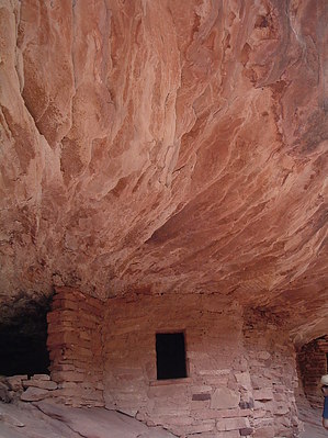
Easy canyon hike on Cedar Mesa by PaleoRob  Mule Canyon is one such canyon. Most folks who have traveled Utah Route 95 between Blanding and Lake Powell are familiar with the name, as some excavated and partially restored ruins are signed along the road. Those ruins, and their trail, are described elsewhere here. Running just north of the Mule Canyon Road Ruins lays the South Fork of Mule Canyon. South Fork runs into North Fork just south of Route 95 and then drains into Comb Wash, at the foot of Comb Ridge, visible to the east from most of Cedar Mesa.
The trail drops across a narrow arroyo from the trail register and then back up onto the other side before crossing a grassy meadow at the bottom of the canyon. The arroyo and road embankment are the most serious elevation changes to contend with for a basic Mule Canyon hike. For the most part, the South Fork of Mule Canyon runs west-northwest for most of its course, with no real side canyons to speak of. At about 1.8 miles, a small draw on the north cliff face can be used to access the mesa top between the North and South forks and can be used as a route to get to North Fork if one desires a loop or backpacking trip. The canyon bottom is flat, with very little of the steep arroyo cutting that marks Grand Gulch. The hiking is very easy, and the trail is quite simple to follow until about 3 miles from the trailhead. The trail deteriorates quickly then, and most turn back here. This is the figure I used to calculate the round-trip distance. In the spring, there is often a flowing stream at the canyon bottom, and there are also seasonal springs up on some of the terraces of the canyon. Check with the Kane Gulch Ranger Station for the latest water information, though - the canyon is generally dry during the summer except for flash floods. Mileage can quickly add up exploring ledges and such for Anasazi traces. The canyon has a fair amount of ruins and rock art, so the pursuit of such will not be in vain. One famous ruin in South Fork of Mule Canyon is Flaming Roof, or House on Fire, Ruin. This cliff dwelling, from the late 1200s, is well preserved and not a far hike from the trailhead. In fact, a quick hike to the canyon rim from the Mule Canyon Road Ruins shows the location of Flaming Roof quite well. I won't give away the specifics, though - discovery is half the fun, and it's not terribly hard besides. Lots of other ruins await the explorer in Mule Canyon. Once you have explored what you feel is enough or have gone to the end of the trail, you return to your vehicle by the same route you came. Check out the Official Route and Triplogs. Leave No Trace and +Add a Triplog after your hike to support this local community. | ||||||||||||||||||||||||||||||||||||||||||||||||||||||||||||||||||||||||||||||||||||||||||||||||||||||||||||||||||||||||||||||||||||||||||||||||||||||||||||||||||||||||||||||||||||||