Route Editor

| Guide | ♦ | 6 Triplogs | 0 Topics |
details | drive | no permit | forecast | route |
stats |
photos | triplogs | topics | location |
| 20 | 6 | 0 |
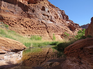
Piggy cleaning stop by nonot  A short hike from a highway rest area. History Hog Springs is a highway rest area with a few pit toilets. There are signs of the usefulness of the spring that you can read along the way. Hike Go over the quaint suspension bridge to an area with a (dancing?) platform and some picnic tables. The hiking trail is signed and continues going along next to the creek. It is slightly overgrown, but the trail is still apparent. Continue hiking upstream next to the creek, there are a few washout sections of the trail to negotiate, but it is not too difficult. The trail will cross the creek at a small cascade of a few feet high. Find a place to cross and continue hiking upstream. After this the trail appears to braid in at least 3 directions. I took the middle one and ended up on a sandy bench overlooking the upper part of the canyon. The proper trail appears to be the one that stays at creek level. Up ahead appear to be a few large pools and intermittent shade.
Water Sources Hog Springs appears to flow year round and the creek is clear when it hasn't rained recently. Camping Several options along highway 95 in the area. Check out the Official Route and Triplogs. Leave No Trace and +Add a Triplog after your hike to support this local community. | |||||||||||||||||||||||||||||||||||||||||||||||||||||||||||||||||||||||||||||||||||||