Route Editor

| Guide | ♦ | 15 Triplogs | 0 Topics |
details | drive | no permit | forecast | route |
stats |
photos | triplogs | topics | location |
| 157 | 15 | 0 |
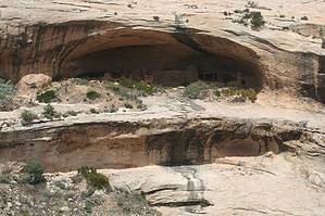
Short hike to ruin overlook by PaleoRob  The Kayenta Anasazi have their nexus in northeastern Arizona, around the Tsegi Canyon system, and their buildings generally lack the fine stonework of either Mesa Verde or Chaco. In Utah, Kayenta Branch sites can be found all over Cedar Mesa and west towards the Colorado River.
Why is all this important? Well this little hike straddles the boundary between two of these groups. Comb Ridge, the massive anticline that you are hiking up, forms the general boundary between the Kayenta and Mesa Verde Branches. This was the border between cultures in the late 1200's. The hike starts in the parking lot. There is a pit toilet, but no water available. Make sure you bring enough water for the hike with you. There is very little shade. The trail heads briefly north from the parking area, and then heads west-northwest across a pinon-juniper stand. The ground is slightly sandy, but not very hard to hike on. The slope you are hiking up is the backside of Comb Ridge. At the crest, it drops 750 clear down to Comb Wash, with hardly a break between its origin on Elk Ridge and the San Juan River, some 30 miles away. This is the barrier to cultural interchange that made Comb Ridge the border that it was 800 years ago. The slope steepens as you hike further. After about a quarter of a mile, you leave the PJ forest and start crossing a slickrock slope. The slope is relatively gentle, and well-cairned. Keep an eye out for the next cairn, and you won't go wrong. If for some reason you loose sight of the trail, head west. Eventually you will reach the rim of a small canyon - it is across this side canyon that the Butler Wash Ruins lay. Butler Wash itself extends all along the east side of Comb Ridge down to the San Juan river, and ruins are numerous. These are essentially the westernmost Mesa Verde Branch site in Utah. Butler Wash ruin itself is in rather poor shape, having been well-known to locals and out-of-town ruin hunters for many years. Still, it is interesting to look at. A few kivas dot its alcove, and some granaries are visible downcanyon in small openings in the cliff. On my last visit there was a sign at the overlook, explaining the ruin in some detail - I am not sure if it is still there. This hike can be extended by hiking around the head of the canyon to reach the ruins and gently exploring. Once you are done viewing or exploring, return to the parking area by the same route. Check out the Official Route and Triplogs. Leave No Trace and +Add a Triplog after your hike to support this local community. | |||||||||||||||||||||||||||||||||||||||||||||||||||||||||||||||||||||||||||||||||||||||||||