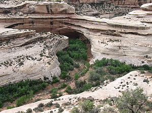
Natural Bridges National Monument, in southeastern Utah, is a small monument with big attractions. The seconds largest natural bridge in the United States resides there, along with two other enormous natural stone spans. Sipapu, the largest of the three, spans Armstrong Canyon. Owachomo, the smallest, crosses a tributary of White Canyon. Kachina, the middle-sized bridge, crosses Armstrong just where it joins into White Canyon. Viewing the junction of these two awesome canyons, with Kachina Bridge connecting two sides of one canyon together, is amazing, and the hike to get there is quite easy. From the parking area at the Kachina Bridge trailhead, head west towards the canyon rim along the trail. The trail drops a few feet quickly as you cross the slickrock mesa top. Shortly after that, the trail to hike to the canyon bottom branches off to the left. It is well signed. The trail to the overlook continues straight ahead. There are a couple benches along the trail, making this trail perfect for those unable to hike long distances, such as those with small children.
The trail eventually dead-ends at the canyon rim. The floor of White Canyon, coming downover a serious pourover to the left, 340 feet below. Armstrong Canyon, the bottom laying under Kachina Bridge, joins White Canyon at the foot of the bridge. The canyon makes a sharp turn there, and heads west, eventually meeting up with Lake Powell at Hite.
Kachina Bridge gets its name from several petroglyphs on the underside ends of the bridge. Early explorers to the Natural Bridges area named the bridges after various parts of goverment, with President, Senator, etc. Kachina was originally Senator. Later the name changed to Caroline, after a local cowboy's mother. It was William Douglas, a government surveyor, who coined the name Kachina, and it has stuck ever since.
The trail ends at a railing-enclosed viewing area, with a couple of informational plaques. The intrepid hiker can continue from here back to the branch, and hike down to the bridge. For those who are not interested in seeing Kachina Bridge closer up, return to the parking area by the same trail you took to the overlook.
There is no water on this trail, and very little shade. Be sure to fill your water bottles at the Visitor's Center.
 Route Editor