Route Editor

| Guide | ♦ | 13 Triplogs | 0 Topics |
details | drive | permit | forecast | route |
stats |
photos | triplogs | topics | location |
| 150 | 13 | 0 |
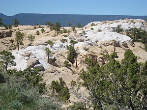
History-filled hike up a NM mesa! by PaleoRob The trail starts from the Visitor's Center and heads towards the cliff face. The trail branches just before getting to the foot of the mesa. When I have hiked this trail, I have taken the path to the right, and will describe it in the same manner.
The natural tank is one of the most obvious draws to the area. Water flowing off the mesa funnels into a small canyon, which drains straight down into the pool. Since this pool is in a shaded hollow, it retains its water all year long. Anasazi hunters and villagers, Spanish conquistadores, and American surveyors have all taken advantage of its life-sustaining location. However you are discouraged from filling your water bottles from the tank. Instead fill your bottles back at the Visitor's Center. After passing the tank, the trail continues to the north, before turning at the NE corner of the mesa, heading west. The trail here is shaded, especially in the morning, and provides a nice respite from the sun during a summer's day. The trail then begins climbing the mesa in a series of steep switchbacks, gaining about 250 feet in a short span, about 1/2 a mile or so. Once you reach the top of the mesa, take a moment to survey the scene before you. Highway 53 runs through the valley, and the Zuni Mountains dominate the northern horizon. The Malpais begins to the east northeast and stretches away. Mt. Taylor can sometimes be seen, depending on the quality of the air. A pile of rubble on the mesa top, to the left of the trail, is one of two major pre-Zuni pueblo ruins on Inscription Rock. This ruin remains unexcavated, in contrast to Atsinna on the far side of the mesa. The trail meanders across the mesa, coming to the rim of Box Canyon, a small canyon running south from the center of Inscription Rock. Box Canyon is steep-walled and inaccessible from the Mesa Trail. After passing Box Canyon, the trail makes its way towards the southeastern corner of the mesa. It is here that the trail crosses the Zuni site Atsinna, which was partially excavated and stabilized in the 1950's. Atsinna means "Place of the Writings on Rocks." Some 1500 people lived in this 875 room pueblo during the collapse and abandonment of most of the rest of the Colorado Plateau between 1275 and 1350. The trail begins down the side of the mesa not long after Atsinna, in another series of switchbacks. This branch meets back up with the main section of the trail not long after returning to the valley floor, and heads back to the Visitor's Center.
Check out the Official Route and Triplogs. Leave No Trace and +Add a Triplog after your hike to support this local community. | ||||||||||||||||||||||||||||||||||||||||||||||||||||||||||||||||||||||||||||||||||||||||||||