Route Editor

| Guide | ♦ | 21 Triplogs | 0 Topics |
details | drive | no permit | forecast | route |
stats |
photos | triplogs | topics | location |
| 487 | 21 | 0 |
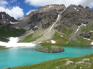
Robert van Winkle approved by chumley This trail leads to Ice Lake Basin, one of the most beautiful high-alpine landscapes you will ever experience. Warning While this trail is well-maintained and easy to follow, it is a very steep 4 miles, gaining nearly 2,500 feet and topping out at over 12,000 feet in elevation. Mountain weather is unpredictable and dangerous storms may develop quickly at any time of year.
The hike begins at the marked trailhead and sign-in box on the north side of the South Mineral Campground at the end of Forest Road 585. The trail climbs steadily for the first half mile where it reaches the crossing of Clear Creek, a short distance below a scenic waterfall. Depending on the water level, crossing the creek here may be difficult to do without getting your feet wet. Once across the trail takes a short detour through an open meadow before ascending several switchbacks and ending up at the top of the waterfall on Clear Creek at the 1 mile mark. The trail switch backs away from the creek again, but most will take the short spur in the wrong direction to see the falls before continuing upward. The next 0.75 mile climbs steadily while traversing a large open slope with views above. Don't be fooled. What you see isn't nearly the top! The rushing creek to the left of the trail as you climb is the flow that drains all the lakes above you. A couple of short spur trails lead to viewpoints and several cascades and waterfalls along the creek. At mile 1.75 the trail turns into the trees and climbs steeply, rounding a ridge and steadily switchbacking until reaching the start of Lower Ice Lake Basin at about 2.4 miles. The next 0.6 miles is a relatively flat trek across the incredibly scenic Lower Ice Lake Basin. A lake sits somewhat below you to the left, while several waterfalls drain from around the basin. Up ahead you see a large cascade tumbling down from above, and the majestic Golden Horn and other peaks above Ice Lake Basin dominate the view. It is here that many choose to set up camp, as there are still pockets of trees. At the 3 mile mark, you will have to cross the stream that drains from Ice Lake above. Once again, the ease of crossing will depend on the amount of water draining from lake. It is entirely possible that a dry crossing here will be impossible. Some will choose to hop through and continue on with wet boots, while others will choose to remove their boots and make the chilly crossing in bare feet. Once across, the trail climbs steadily, again with waterfalls on the left. It's about .75 miles and 750 feet of additional gain before the trail crests the hill and enters Ice Lake Basin. From here it's a short quarter mile to the shores of the impossibly blue Ice Lake. Once reaching the lake, you can return the 4 miles back to the trailhead (as the stats on this page describe), or explore more of Ice Lake Basin: A trip south to Fuller Lake will add about 2 miles round trip and gain over 300 additional feet. A trip northeast to Island Lake will add a little over a mile round trip and gain about 150 feet very steeply. Several of the peaks that rise above Ice Lake Basin can be climbed by ambitious hikers. Fuller, Vermilion, Golden Horn, Pilot Knob, and Ulysses S. Grant all rise to above 13,700 feet. Camping Camping is permitted and several undeveloped sites are available in the wooded areas of Lower Ice Lake Basin. Please remember to camp at least 100 feet from any lake or stream. Check out the Official Route and Triplogs. Leave No Trace and +Add a Triplog after your hike to support this local community. | ||||||||||||||||||||||||||||||||||||||||||||||||||||||||||||||||||||||||||||||||||||||||||||||||||||||||||||||||||||||||||||||||||||||||||||||||||||||||||||||||||||||||||||||||||||||||||||