Route Editor

| Guide | ♦ | 5 Triplogs | 0 Topics |
details | drive | no permit | forecast | map |
stats |
photos | triplogs | topics | location |
| 54 | 5 | 0 |
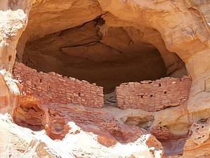
Beautiful wilderness hike in SW Colorado by PaleoRob  Despite this, COANM, like most of the other Clinton-BLM monuments, remain little developed. There are, however, a few developed trails, and one such is the East Rock Creek Loop. Before embarking on this, or any other hike in COANM, it is highly recommended that you stop by the BLM's Anasazi Heritage Center on the southwest shore of McPhee Reservoir, north of Cortez. They have maps, trail guides, and information about COANM as well as other local natural and historic attractions. The hike shares a trailhead with the Sand Canyon Trail, at Castle Rock. The trail starts out rising over the slickrock platform between the highway in McElmo Canyon and Castle Rock. Castle Rock Pueblo, which takes its name from the prominent fin of rock, sprawled not only over the top of the fin, but down its sides as well, before it was destroyed during the abandonment of the Colorado Plateau by the Anasazi. Before the site was excavated, the story of its destruction and abandonment was told to early American explorers by Hopi elders. Much to many people's surprise, many facets of the story were corroborated by the excavation. You can still see traces of walls and even one floor, high up on the cliff over a crack.
Climbing the slickrock bench further, the trail branches when it meets with the headlands of low mesa. The rocks of Sand Canyon are sedimentary, sand and silt laid down in the Mesozoic Era in successions of seas and bayous where dinosaurs roamed. Now these layers break the canyon up into different layers, with the harder sandstones forming cliffs and the softer siltstones forming slopes between them. On the East Rock Creek Loop, most of the ruins you will come across are sheltered in alcoves in the Entrada Sandstone, the rock that forms the cliff face at the split of the trail. You can hike the trail in either direction, but I hiked it going on the east fork first, so I'll describe it thus. Hike: The trail follows the foot of the Entrada cliffs through the low pinon and juniper forest. The hiking is easy here, the trail packed sand and rock over a lightly undulated bed. The forest doesn't provide much shade, so taking breaks if hiking in the summer must be carefully picked. Several spur trails take off from this trail to explore embayments in the cliff face, with hoodoos, mini arches, and the occasional ruin. The most visible and well-known ruin on this section of the trail is Saddlehorn Pueblo, a small Pueblo III ruin in an alcove below a saddlehorn-shaped hoodoo. While probably not housing many people, it is well preserved due to the sheltering overhang. Not long past Saddlehorn, the trail branches, with the Sand Canyon Trail continuing upcanyon, ending up at Sand Canyon Pueblo. The East Rock Creek Trail branches off to the west, and begins climbing. This starts the toughest stretch of the trail as you climb up the bajada separating Sand Canyon from East Rock Creek in a series of switchbacks. The summit of the mesa is at 5894 feet above sea level, only about 100 feet above the point where the trail branched, and this is the highest point on the trail. From the trail as it crosses the bajada there are great views down into East Rock Creek and its tributaries. Some cliff dwellings are even visible from this section of the trail. As the trail drops down into East Rock Creek, you pass a small "doghole" uranium mine. During the big uranium boom in the 1950's and 60's, uranium prospecting and mining was very big business in southwestern Colorado and southeastern Utah. Yellow material around the mouth of the mine might be carnotite, which is uranium ore. From here the trail drops rapidly to a bench above the tributaries of East Rock Creek. An old mine road, which probably serviced the small mine the trail passed, serves as the trail bed during this section. As you hike along, you'll begin noticing more Anasazi ruins. Some of the ruins in East Rock Creek are easily accessible as side-trips from the main trail, while others are not. The trail then rises, crossing another divide between tributary drainages, and then drops and bends east again, coming around the southern fingers of the mesa. It is here that Anasazi ruins really take off, where it seems that every bend of the trail, every alcove contains some ruin. Several of these are not able to be entered easily, but others can be climbed into with little difficulty. Soon after passing the last of the Anasazi ruins on the East Rock Creek side of the trail, you meet back up with the main trail coming up from Castle Rock. Return to your vehicle from here, down the slickrock plain past Castle Rock. There is no water on this trail, except the occasional slickrock pothole that may have been rained-in recently. Do not count on these for water - bring all you need. The trail is hikable in summer, since temperatures are not extreme, but make sure you stop in shady spots and ruins to rest.
Check out the Triplogs. Leave No Trace and +Add a Triplog after your hike to support this local community. | ||||||||||||||||||||||||||||||||||||||||||||||||||||||||||||||||||||||||||||||||