Route Editor

| Guide | ♦ | 1 Triplog | 0 Topics |
details | drive | permit | forecast | map |
stats |
photo | triplog | topics | location |
| 1 | 1 | 0 |
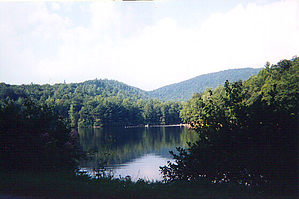
Hidden gem in North GA by Crzy4AZ  The lake is named for a US army legend Winfield Scott born in 1786 who served as a military officer in the War of 1812, the Mexican American war, and even at age 75 was the commanding officer of the US Army at the start of the Civil War. I find it odd that a lake in North GA would be named for the man who proposed the "Anaconda" strategy that ultimately led to the North's victory over the South. Unfortunately Winfield Scott is also known for implementing the orders from Andrew Jackson to lead the Cherokee on the Trail of Tears out of Georgia and surrounding states.
The narrow winding Highway 180 that leads to Lake Winfield Scott is slow going, but it's worth the extra driving time to take in this gem. You are surrounded by forests up to the lake's edge and have hiking options ranging from a leisurely walk around the lake's edge (0.4 mi RT) to a 6-8 mile loop hike on the Appalachian Trail (AT). Drinking a cold beer at dusk in the heat of summer is quite the d'nouement to a long day of hiking and swimming. The 6 - 8 mile loop hike begins at the boat launching area with TH for Slaughter Gap trail. Take Slaughter Gap trail (blue markers) 2.2 miles to the junction with the AT (white markers) and you have two options. Go two miles round trip to Blood Mountain peak (4458 ft) and back or go to the right and continue the loop on AT another 2.3 miles to Jarred Gap (3300 ft). Take Jarred Gap 1.2 miles back to the lake... and jump in! Check out the Triplog. Leave No Trace and +Add a Triplog after your hike to support this local community. | |||||||||||||||||||||||||||||||||||||||||||||||||||||||||||||||||||||||||||||||||||||||