username
X
password
register
for free!
help
 

Sand Island, UT

Guide 11 Triplogs  0 Topics
  3.8 of 5  
Fav
Wish
1
details
drive
no permit
forecast
map
stats
photos
triplogs
topics
location
48 11 0
HAZ reminds you to respect the ruins. Please read the Archaeological Resources Protection Act of 1979 & Ruins Etiquette
Statistics
tap row or icons for details
Difficulty 0.5 of 5
Route Finding 1 of 5
Distance Loop 0.25 miles
Trailhead Elevation 4,294 feet
Elevation Gain 30 feet
Avg Time Round Trip 0.5 hours
Kokopelli Seeds 0.4
 Interest Off-Trail Hiking & Ruins
 Backpack No
unreported if dogs are allowed
editedit > ops > dogs to adjust
feature photo
Photos Viewed All MineFollowing
6  2018-01-02 Stoic
8  2015-07-22 AZWanderingBear
25  2014-07-07 big_load
9  2006-03-23 PaleoRob
Author
author avatar Guides 171
Routes 253
Photos 6,100
Trips 1,135 map ( 2,556 miles )
Age 44 Male Gender
Location Pocatello, ID
Associated Areas
list map done
Southeast Region
Historical Weather
Trailhead Forecast
Expand Map
Preferred Oct, Mar, Apr, Nov
Seasons   ALL
Sun  5:52am - 6:42pm
0 Route
 
0 Alternative


Fast, easy hike for some awesome rock art!
by PaleoRob

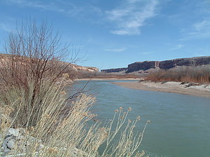
The southwest in general, and southern Utah in particular, is known for its profusion of prehistory. Anasazi ruins and rock art dot the landscape, from great National Parks and Monuments, to little, out of the way tiny sites that no one ever sees. Sand Island is sort of in between the two. It isn't part of some grand National Park like Zion or Mesa Verde. It also isn't a pile of rubble or two antelope scratched into a rock, someplace in the middle of nowhere. Sand Island is amazing. A cliff face stretching for a length of hundreds of feet above the San Juan River, and it is simply covered with petroglyphs. Some are very old, probably dating back thousands of years, while others were made much more recently; maybe as recently as the last 100 years by nomadic Utes. Sand Island has been used as a stopping ground, obviously, for many people for many hundreds of years.


From where you parked you car, look up at the cliff face looming to your north. Some of the images should reach out to you and be visible already. There is no defined trail really, leading up through the talus slope to the cliff. There are, however, several worn informal paths. Follow any one of these, and you'll soon find yourself at the base of the cliff where the images begin.
remove free decal offer
Some common images include bighorn sheep, both large and small. Bighorn sheep likely played a large role in the life of the local Anasazi as a source of food. A large herd of bighorn sheep now roams the San Juan River corridor, just downstream from Bluff. Other images include feet, snakes, and zig-zags. What do they mean? No one knows for sure. Perhaps the feet mean migration. The snakes could mean snakes. Or water. Or prayer. Or something else entirely. Some people think that the zig-zags are maps, specifically maps of the San Juan River. It could be. As you walk along the cliff face, come up with your own idea. Who knows, maybe you'll turn out to be right.

After you've seen as much of the cliff as you want, or if you're done with the main section, return to your vehicle by any path you can find. Other petroglyphs are present in the Sand Island area, and the intrepid explorer can usually locate some of them.

2008-01-13 PaleoRob


    Check out the Triplogs.
    Leave No Trace and +Add a Triplog after your hike to support this local community.
    WARNING! Hiking and outdoor related sports can be dangerous. Be responsible and prepare for the trip. Study the area you are entering and plan accordingly. Dress for the current and unexpected weather changes. Take plenty of water. Never go alone. Make an itinerary with your plan(s), route(s), destination(s) and expected return time. Give your itinerary to trusted family and/or friends.

     Permit $$
    None


     Directions
    or
     Road
    FR / Dirt Road / Gravel - Car Okay

    To hike
    From Bluff, Utah, drive west of US163/191. Turn left onto the Sand Island Road, signed for BLM/Sand Island. There is a campground, launch ramp for river trips, and restrooms all at Sand Island. As you come down the hill into the Sand Island area, the launch ramp will be to the left, and the campground will be to the right/straight ahead. Take the road to the right, following the base of the cliff, until you come to a dirt pull out next to a talus slope. Petroglyphs should be visible on the cliff face. Park your car here. The dirt road ends in a cul-du-sac, so when leaving, if you have a larger vehicle, you can turn around there.
     90+° 8am - 6pm kills
    helpcorrectionissue

    end of page marker