Route Editor

| Guide | ♦ | 9 Triplogs | 0 Topics |
details | drive | permit | forecast | route |
stats |
photos | triplogs | topics | location |
| 172 | 9 | 0 |
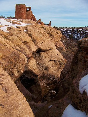
The most accesible of Hovenweep's hikes. by PaleoRob  The trail starts out at the visitor center, and heads south towards Little Ruin Canyon. The trail is well maintained and soon reaches the rim of the canyon. The trail branches at this point. I have always hiked this trail going to the left here, and will describe it as such.
Heading downcanyon, the trail generally follows the rim. The trail then branches again, with one branch dropping into the canyon with the other continuing along the rim. The rim trail eventually leads to the campground, so here you are going to want to follow the trail into the canyon. The canyon is not very deep, and through a few switchbacks you are quickly deposited at the canyon bottom. As you hike into the canyon, as well as on your way out, look for black bands of crumbly rock in the canyon wall. There are coal seams throughout the area, as well as natural gas deposits. You probably noticed some natural gas wells on the drive to the monument. After crossing Little Ruin Canyon, which indeed is not very wide or deep, you climb out with a steep, but not long haul. The trail now continues following the rim of the canyon along the west side of the canyon. It is not far from where you emerge back onto the rim when you reach the first serious ruin of the trail; Twin Towers. Moving on upcanyon on the rim from Twin Towers, you come across Rimrock House. Rimrock House may not have been in fact a house; it lacks clear room divisions and has peephole like openings in its walls, a feature common to some ruins across the region. Take a moment at this point to look down into Little Ruin Canyon and examine the remains of Round Tower. Its base was nearly perfectly circular and likely stood 2 stories tall. There is a long stretch then between Rimrock House and the next ruin and stop on the trail guide. While you walk along this stretch, be sure to look back and enjoy the view as Little Ruin Canyon frames Sleeping Ute Mountain. There are also good views to Eroded Boulder House and back across the Stronghold House. Notice the debris on the slope below Stronghold House... it gives some sense of how big the pueblo would have been 800 years ago. The next major ruin, right near the head of the western branch of Little Ruin Canyon, is Hovenweep House. From what remains on the rim you can easily tell it was a massive structure. In fact it was part of the one of the largest villages in the Little Ruin Canyon area. Take time to examine the careful masonry. Across the head of the canyon from Hovenweep House is Hovenweep Castle. During its heyday it was a sprawling complex that climbed up from the terraced gardens on the canyon bottom all the way up to its towers soaring above the rim. The debris piles around the base of the remaining structures hints at its massiveness. Also visible in the canyon is Square Tower. Perched on a boulder, Square Tower sits near the spring at the head of the canyon. In conjunction with the two massive villages on either side of the canyon (Hovenweep Castle and House), this area of the canyon seems to be set up to defend the spring. Certainly it would do a good job at that, but is that what the buildings were constructed for? Moving on from Hovenweep House, the trail crosses a small draw above the head of Little Ruin Canyon. Here the Anasazi built a small check dam to capture water during times of runoff. This allowed more water to eventually percolate down to the spring below, as well as providing a little bit of arable land on the slickrock expanse of the rim. The remains of the check dam can be seen from this point. Hovenweep Castle is probably the most impressive structure on the Little Ruin Canyon loop, and rightfully so. Not only is it the largest standing structure on the trail, but it also has a lot of interesting archaeological features to it as well. It is highly recommended to pick up the trail guide if for no other reason than to see the beautiful reconstruction of the Hovenweep Castle community it has. It's quite a contrast to see what remains now and what existed back then. At Hovenweep Castle the trail splits. Taking the right-hand fork takes you out to Tower Point, were the remains of a tower stands on the rim. There are great views downcanyon, as well as into alcoves on both branches at the head of Little Ruin Canyon where the remains of granaries and other structures can be seen. Directly below Tower Point, generally not open to the public, are some petroglyphs, including one that appears to show a parrot perched on a T-shaped doorway. This symbol is part of the Hovenweep National Monument logo, and can also be seen on the trail guide and some signs in the Visitor's Center. Taking the Tower Point segment of the hike will add .5 miles to the whole hike, bringing the total to 2 miles. After passing the head of the eastern branch of Little Ruin Canyon, the trail follows the east rim through pinon and juniper forest, occasionally with a nice glimpse back into the canyon. Just before meeting up with the trail back to the Visitor's Center, you come across one more ruin; Unit Type House. Also known as a unit pueblo for its standardized construction style across the southwest, Unit Type House is a great example of the typical features found in a unit pueblo. From there the trail meets back up with itself at Stronghold House. Take the trail back to the Visitor's Center, where you can look at the exhibits, or get a trail guide and information about one of the other 3 units of Hovenweep National Monument.
Check out the Official Route and Triplogs. Leave No Trace and +Add a Triplog after your hike to support this local community. | ||||||||||||||||||||||||||||||||||||||||||||||||||||||||||||||||||||||||||||||||||||||||