 Route Editor

| Guide | ♦ | 23 Triplogs | 0 Topics |
details | drive | permit | forecast | route |
stats |
photos | triplogs | topics | location |
| 104 | 23 | 0 |
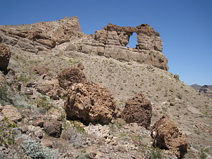
A Revolutionary Experience by AZLOT69  Overview OverviewThis awesome hike runs parallel to the White Rock Canyon after leaving it. The Liberty Bell takes the high road as the White Rock Canyon takes the low road. The result is at the end of the Liberty Bell Trail, about a third mile past the arch, you look down a sheer cliff of one thousand feet to White Rock Canyon below and the Colorado River. The acoustics in White Rock Canyon is so good you can hear people walking in the wash and hear the conversations from above. Views from above include the campsites for Arizona Hot Springs and the new bypass bridge for the Hoover Dam. Warning There is no shade available on this hike. The intense sun on the dark rock can make for a very uncomfortable day if you are not prepared.
From the White Rock Canyon Trailhead head west. The trail goes downhill steadily and eventually drops sharply into a sheer rock wash. The wash becomes lined with rocks about twenty feet tall on both sides and continues to rise. At about three-quarters of a mile into the hike dark volcanic rock walls appear in front of you. There are red rocks now in the wash you are walking in. There is a high wash entering above you to the right. Turn right just before the red rocks start to avoid a dry fall and contour around and up to this wash. If you miss the unmarked turn and continue in White Rock Canyon you will know you went too far if the canyon makes a sharp right, then sharp left and there is a large white boulder to negotiate. Turn around and follow the prior directions. This high wash you are now proceeding in is an old miners access road which from time to time you will see some signs of rock work. Soon you pass a mining claim marker and soon after a trail divide. Turning right will take you back to highway 93, so bear left up the hill. It is pretty obvious where this was once a road. There is another mining claim marker on your right. After a dip, you will find a mine on top of the next hill with some artifacts still around. This was a magnesium mine. There are a few trails off to the right to explore the area but the main trail bears left. The trail now descends to a wash. Try as you will from this point you can not see the arch from any vantage point yet. It's close though. It's in the light-shaded superstructure of mountains right in front of you but at a right angle. As the trail swings north the arch slowly comes into view. Another trail joins here from the right. This is another alternate trail back to highway 93. Bear left, the trail continues south, losing sight of the arch again and then a full view of it looking to the north. You can also see the Hoover Dam bypass bridge from here. It's only another third of a mile now to the overlook of the Colorado River. It's uphill and rocky but you would be remiss to pass up this opportunity. Be prepared for several false saddles. At the first view of the Colorado River sneak up to the edge and look down and listen. The popular White Rock Canyon Trail is directly below. Continue now to the top for wonderful views in all directions. When done return the way you came. Check out the Official Route and Triplogs. Leave No Trace and +Add a Triplog after your hike to support this local community. One-Way Notice This hike is listed as One-Way. When hiking several trails on a single "hike", log it with a generic name that describes the hike. Then link the trails traveled, check out the example. | |||||||||||||||||||||||||||||||||||||||||||||||||||||||||||||||||||||||||||||||||||||||||||||||||||||||||||||||||||||||||||||||||||||||||||||||||||||||||||||||||||||||||||||||||||||||||||


