Edge of the Cedars, UT • Hike
  

Edge of the Cedars, UT

Guide 5 Triplogs Mine 0 0 Topics
 
3.7 of 5 
Fav
Wish
0
details
drive
permit
forecast
map
stats
photos
triplogs
topics
location
63 5 0
HAZ reminds you to respect the ruins. Please read the Archaeological Resources Protection Act of 1979 & Ruins Etiquette
Statistics
tap icons for details
Difficulty 1 of 5
Route Finding 1 of 5
Distance Loop 0.3 miles
Trailhead Elevation 6,164 feet
Elevation Gain 6 feet
Avg Time Round Trip 1 hour
Kokopelli Seeds 0.33
 Interest Ruins
 Backpack No
unreported if dogs are allowed
editedit > ops > dogs to adjust
feature photo
Photos Viewed All MineFollowing
3  2021-05-03 AZLOT69
49  2018-04-13
Nine Days - Cedar Mesa Comb Ridge (Part 2)
AZWanderingBear
11  2006-03-24 PaleoRob
Author
author avatar Guides 172
Routes 229
Photos 6,096
Trips 1,129 map ( 2,527 miles )
Age 41 Male Gender
Location Pocatello, ID
Associated Areas
list map done
Southeast Region
Historical Weather
Trailhead Forecast
Expand Map
Preferred Oct, Apr, May, Sep
Seasons   ALL
Sun  7:04am - 6:00pm
Route
 
0 Alternative
 
 Water
Nearby Area Water
[ View More! ]
Culture  Nearby
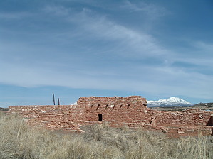
Great museum at a Utah Chacoan site
by PaleoRob

Edge of the Cedars State Park, located in Blanding, Utah, showcases one of the northwestern-most Chacoan outliers. Partially restored, the pueblo still stands some two stories tall. But the Edge of the Cedars Pueblo is only one of the attractions of this state park. The adjacent museum houses one of the most amazing collections of Anasazi artifacts in the southwest. Some were excavated at Edge of the Cedars, while others come from all over the southeastern portion of Utah. With a low admission, this is one stop that is more than well worth its cost.
The trail to the ruin starts at the back door of the museum. Make sure that you have looked around in the museum before heading out on the hike, there is tons of useful information and great displays that will help you really picture this site as it was 800 years ago. The trail is paved, except for one spur, and is suitable for wheelchairs and strollers. It branches almost immediately upon leaving the museum. The left branch heads directly towards the ruin, while the right branch swings around an unexcavated portion of the ruin, and offers a great view of the Abajo Mountains, just to the northwest of town. This ruin was actively dug up by locals for many years before it became a State Park, and many sites around town bear witness to this as well. You may notice some indentations in the soil around the trail, now grown over. These are "pot holes" where looting occurred in the past.

There is a gravel spur trail that leads down to what can only be described as an odd structure. It is a solar marker, designed by a local artist, that combines Anasazi symbolism with other imagery, light, and shadow. It is supposed to highlight the solstices and equinoxes, but I have not been there during one of these events.

Back at the pueblo, you can actually climb on the restored roof of one of buildings, and descend a ladder into a kiva. It is dark and can be hot, especially in the summer, but it is certainly an experience worth having. The trail also winds around the sunken remains of a Great Kiva in the plaza. From here you can see Sleeping Ute Mountain, the Chuskas, and Shiprock - what a view these folks had! After enjoying the pueblo, return to the museum, where you will surely want to look at more of what they have to offer.

Check out the Triplogs.

Leave No Trace and +Add a Triplog after your hike to support this local community.

2008-01-18 PaleoRob
    WARNING! Hiking and outdoor related sports can be dangerous. Be responsible and prepare for the trip. Study the area you are entering and plan accordingly. Dress for the current and unexpected weather changes. Take plenty of water. Never go alone. Make an itinerary with your plan(s), route(s), destination(s) and expected return time. Give your itinerary to trusted family and/or friends.

     Permit $$
    $3/person. For more information about special exhibits or programs, call (435) 678-2238. Park Information


     Directions
    or
    or
     Road
    Paved - Car Okay

    To hike
    From "downtown" Blanding, at the stoplight (the junction of Center and Main, on US191), head west on West Center Street 6 blocks, until the pavement ends. Turn right (north) here at North 600 West. The museum and ruins will be on your left, at the junction of N600W and W400N (street address 660 West 400 North).
    helpcorrectionissue

    end of page marker