Route Editor

| Guide | ♦ | 15 Triplogs | 0 Topics |
details | drive | permit | forecast | route |
stats |
photos | triplogs | topics | location |
| 244 | 15 | 0 |
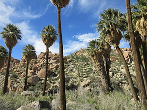
Lost Palm Oasis: Found! by Jim  Leaving from Cottonwood Springs, pass through the lovely oasis vegetation of tall palms and cottonwoods. Pass the intersection for the loop to Mastodon Peak, and continue on this lovely trail to the Oasis. Along the way, you'll enjoy fantastic upper Colorado (Sonoran) Desert scenery, views of boulder fields in the Eagle Mountains, and distant desert vistas. You might look back and catch a glimpse of San Gorgonio, but probably not San Jacinto, above some of Joshua Tree National Park's Little San Bernardino Mountains. If in winter or spring of a good year, San Gorgonio will be snow-covered. A small portion of this hike follows a sandy wash, but most is on the uplands.
At the time of this writing, near the lower end of the oasis, a different kind of palm has been seeded in, most likely by human (not me) sources. A true date palm of about 3 or 4 years of age, is currently growing. In time, this may get larger and become an addition to the oasis, or the NPS may correctly choose to remove it as an exotic species. Date palms are dioecious and are either male or female. This is probably a seed from one of the local Medjol Dater Palm orchards, brought in during someone's lunch, and growing after being left behind. A single date palm, being male or female, will be unable to reproduce in this isolated location. However, it can create a small colony by pupping, or growing side stems from near the ground. Check out the Official Route and Triplogs. Leave No Trace and +Add a Triplog after your hike to support this local community. | |||||||||||||||||||||||||||||||||||||||||||||||||||||||||||||||||||||||||||||||||||||||||||||||||||||||||||||||||||||||||||||||||||||||||||||||||||||||||||||||||||||||||||||||||||||||||||||||