 Route Editor

| Guide | ♦ | 114 Triplogs | 3 Topics |
details | drive | no permit | forecast | route |
stats |
photos | triplogs | topics | location |
| 1.5k | 114 | 3 |
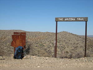
eye of the tiger by HAZ_Hikebot  From the Tiger Mine Trailhead, the trail proceeds in a twisting NNW direction for approximately 5.5 miles until reaching a 3-way pipeline road intersection. Over this section you will descend into and cross several distinct washes, all of which are about a mile apart; eventually reaching the largest wash, which is Tucson Wash. After climbing out of Tucson Wash the trail will gently curve around to a true north direction as you traverse several ridges, one gate, a dirt road, and soon arrive at the pipeline intersection. At this junction, there will be a large white steel gate on the east side signifying private land owned by El Paso Gas. The newly constructed trail now continues in a twisting northerly direction for approximately 10.5 miles to the confluence of Camp Grant and Bloodsucker Washes. Over this distance, you will traverse many water drainages, unique rock formations, and 360? scenic views as you climb up and over the ridgeline of the Black Hills. Antelope Peak will consistently be the prominent landmark as the trail meanders northward, as will the Superstitions and Pinal Mountains. To the east lies the entire Galiuro Mtn. Range and the San Pedro River with Mt Graham (10,720') in the background. Looking to the south will be both the Rincon and Santa Catalina Mountains, with Mt Lemmon at 9,160'. When viewing to the east you will get a good idea of how expansive the Sonoran Desert is as it transitions from low to high desert. From the Tiger Mine Trailhead, the trail proceeds in a twisting NNW direction for approximately 5.5 miles until reaching a 3-way pipeline road intersection. Over this section you will descend into and cross several distinct washes, all of which are about a mile apart; eventually reaching the largest wash, which is Tucson Wash. After climbing out of Tucson Wash the trail will gently curve around to a true north direction as you traverse several ridges, one gate, a dirt road, and soon arrive at the pipeline intersection. At this junction, there will be a large white steel gate on the east side signifying private land owned by El Paso Gas. The newly constructed trail now continues in a twisting northerly direction for approximately 10.5 miles to the confluence of Camp Grant and Bloodsucker Washes. Over this distance, you will traverse many water drainages, unique rock formations, and 360? scenic views as you climb up and over the ridgeline of the Black Hills. Antelope Peak will consistently be the prominent landmark as the trail meanders northward, as will the Superstitions and Pinal Mountains. To the east lies the entire Galiuro Mtn. Range and the San Pedro River with Mt Graham (10,720') in the background. Looking to the south will be both the Rincon and Santa Catalina Mountains, with Mt Lemmon at 9,160'. When viewing to the east you will get a good idea of how expansive the Sonoran Desert is as it transitions from low to high desert.Traversing this 10.5-mile section, you will pass through 3 cowboy-style gates, cross 5 ranch dirt roads, and possibly observe many nearby old cattle tanks, broken windmills, and abandoned wells. Near the middle of this stretch and within view from long distances is a large active water tank, named Mountainview Tank. Water is pumped up to this 40K gallon tank from lower wells, which then gravity feeds numerous smaller tanks across many miles of the cattle ranch. Once past the tank area and for the next 2 miles, the trail crosses one more ranch road and winds around numerous drainages and smaller ridgelines. There is ample signage, both cairns, and carsonites, to assist in traversing this decomposed granite terrain as the trail gently turns to the west and climbs to a high ridgeline. Most likely, you will have cattle for company; they too like the elevation and cooler breezes this ridge provides. This is the final ridge before dropping down to the confluence of Camp Grant and Bloodsucker Washes. At this point, the trail drops directly into the ever-changing wash, crosses to a 'tree-like island', and then traverses the rest of the confluence, with numerous carsonite signage, until reaching a two-track ranch road.
Southern Trailhead: Tiger Mine Trailhead - Tiger Mine Road Northern Trailhead: Freeman Road Gate Policy: If a gate is closed upon arrival, leave it closed after you go through. If it is open, leave it open. Leaving a closed gate open may put cattle in danger. Closing an open gate may cut them off from water. Please be respectful, leave gates as found. The exception is signage on the gate directing you otherwise. Check out the Official Route and Triplogs. Note This is a more difficult hike. It would be unwise to attempt this without prior experience hiking. Leave No Trace and +Add a Triplog after your hike to support this local community. One-Way Notice This hike is listed as One-Way. When hiking several trails on a single "hike", log it with a generic name that describes the hike. Then link the trails traveled, check out the example. | ||||||||||||||||||||||||||||||||||||||||||||||||||||||||||||||||||||||||||||||||


