 Route Editor

| Guide | ♦ | 13 Triplogs | 0 Topics |
details | drive | no permit | forecast | route |
stats |
photos | triplogs | topics | location |
| 60 | 13 | 0 |
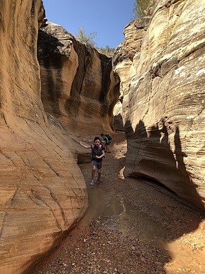
Easily accesible slot canyon in the GSENM. by PaleoRob  Willis Creek is a tributary of the Paria River and starts on the flat sandy benches above Indian Hollow, just south of Cannonville. Parking is on the north side of the wash, which is usually dry, where there is a metal trail register. Sign in here, to let the land managers of the Grand Staircase-Escalante National Monument know how many people are using Willis Creek's slot. There is not much of a trail. Instead, the route simply follows the wash bottom of Willis Creek. Although Willis Creek is usually dry, there may be seasonal puddles of water to contend with and the resultant quicksand. These are most common after periods of rain. The slot begins shortly after leaving the parking area, becomes about waist-deep. If you're thinking "Is this it?" at this point, don't worry. While this mini-slot and small pour-overs are neat-looking, especially when water is running, the main attraction is up ahead.
After about one and a quarter miles Averett Canyon opens on your left. You have two options here: You can make this a loop hike by hiking up Averett Canyon, out to the Skutumpah Road, and down the road back to the trailhead. This would make the hike a 3.7-mile loop. The other option is to continue down to where Willis Creek ends at a T junction with another canyon, approximately 2.25 miles from the trailhead. From there you would turn around and hike back up Willis Creek to the trailhead, the same way you arrived. Either option is acceptable, and both are beautiful. Willis Creek, after Averett, continues to deepen but never gets back to the same width-height ratio making it a slot. There are also a few scattered petroglyphs after the first section of narrows that are worth looking for. There is no water along this hike except at pools after it has been raining. You do not want to do this hike during periods when the creek is flowing, due to the danger of flash flooding. Fill your water bottles at Cannonville, just north of the trailhead, or in Kanab, if you're going to be coming the Johnson Canyon/Skutumpah Road way. If you plan to camp overnight, make sure you get a free camping permit from the GSENM Visitor's Center in either Kanab or Cannonville. Check out the Official Route and Triplogs. Leave No Trace and +Add a Triplog after your hike to support this local community. One-Way Notice This hike is listed as One-Way. When hiking several trails on a single "hike", log it with a generic name that describes the hike. Then link the trails traveled, check out the example. | |||||||||||||||||||||||||||||||||||||||||||||||||||||||||||||||||||||||||||||||||||||||||||||||||||||||||||||||||||||||||||||||||||||||||||||||||||||||||||||||||||||||||||||||||||||||||


