username
X
password
register
for free!
help
  

Double Arch, UT

Guide 28 Triplogs  0 Topics
  3.7 of 5  
Fav
Wish
1
details
drive
permit
forecast
route  
stats
photos
triplogs
topics
location
102 28 0
Statistics
tap row or icons for details
Difficulty 1.5 of 5
Distance Round Trip 0.5 miles
Trailhead Elevation 5,120 feet
Elevation Gain 100 feet
Avg Time Round Trip 0.5 hour
Kokopelli Seeds 1
 Backpack Possible - Not Popular
unreported if dogs are allowed
editedit > ops > dogs to adjust
feature photo
Photos Viewed All MineFollowing
Inaugural Calculation on Button Tap!
20  2022-06-12
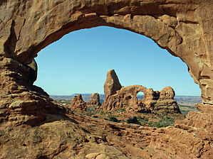
Windows and Double Arch
markthurman53
8  2016-11-09
Landscape Arch
afrankie
10  2016-06-23 cw50must
23  2016-04-20
Arches National Park Trails
trekkin_gecko
7  2014-09-28 AZWanderingBear
3  2014-07-27 leonesiegel
5  2014-06-30
Windows - Arches NP
MikeS
1  2014-05-25 trailzrus
Page 1,  2,  3
Author
author avatar Guides 171
Routes 253
Photos 6,100
Trips 1,135 map ( 2,556 miles )
Age 44 Male Gender
Location Pocatello, ID
Associated Areas
list map done
Southeast Region
Historical Weather
Trailhead Forecast
Radar Map
Expand Map
Preferred Oct, Apr, May, Mar
Seasons   Early Autumn to Late Spring
Sun  5:51am - 6:42pm
Official Route & 1 Rt
 
2 Alternative


An awe-inspiring set of arches!
by PaleoRob

Arches National Park, in eastern Utah, is probably the states most famous National Park. Hundreds of arches cover the park, ranging from massive structures to little tiny keyholes peeking out of sandstone fins. Some require arduous backcountry hikes to reach, while others can be viewed from the road, and a short trail can take the less adventurous visitor to some of them.


Double Arch is one such readily accessible arch, or rather; set of arches. These two connected arches can not be seen from the main loop road, but can be seen from the Windows road and parking area. It is in this parking area that the Double Arch trail starts.
remove free decal offer
After parking your car on the north side of the parking area loop, you will notice a sandy trail branching north towards the opening of Double Arch. The hike is short but pretty, bordered on either side by gorgeous red Entrada sandstone fins. There are several alcoves on the northern fin; who knows, maybe they will become arches in a few thousand years? The trail is sandy but not difficult, and there is not much of a gradient. The only real elevation gain comes at the arch, if you wish to go further up in between the two arches. If you climb to the farthest point of the back wall, you end up gaining about 100 feet from the trailhead, but most people simply stop at the entrance of the slickrock just inside to gaze around. Its a really remarkable sight, especially if there is no one else visiting (a rare occurance). Spend some time there, admiring the view, then return to your car by the same route you came in on. If you feel like another quick hike the Windows Loop takes off on the southeastern side of the same parking area.

Please note there is no water available on this hike: fill your water bottles back in Moab or at the Visitor's Center.

2008-01-28 PaleoRob


    Check out the Official Route and Triplogs.
    Leave No Trace and +Add a Triplog after your hike to support this local community.
    WARNING! Hiking and outdoor related sports can be dangerous. Be responsible and prepare for the trip. Study the area you are entering and plan accordingly. Dress for the current and unexpected weather changes. Take plenty of water. Never go alone. Make an itinerary with your plan(s), route(s), destination(s) and expected return time. Give your itinerary to trusted family and/or friends.

     Permit $$
    NPS

    Arches National Park
    Vehicles: $10 (Good for 7 days) Fee Information


     Directions
    or
     Road
    Paved - Car Okay

    To hike
    From Moab, Utah, drive north on US191 to the Arches National Park entrance station. Pay the fee and proceed down to the Park Road until you reach the Windows Road (signed for the The Windows and Double Arch). Turn right onto the Windows Road, and park at the parking area at the end of the road.
     90+° 8am - 6pm kills
    helpcorrectionissue

    end of page marker