Route Editor

| Guide | ♦ | 4 Triplogs | 0 Topics |
details | drive | permit | forecast | route |
stats |
photos | triplogs | topics | location |
| 63 | 4 | 0 |
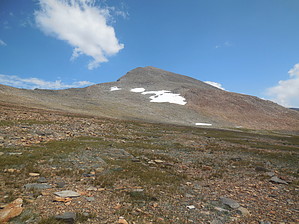
number two by trekkin_gecko Mount Dana is the second highest peak in Yosemite National Park at 13,057 feet. The highest is Mount Lyell at 13,120, but that peak requires a technical climb to summit. A well worn and distinct use trail goes from the Tioga Pass entrance station to the visible peak. The trail begins at a large tree that the ranger pointed out to us. It's a straightforward hike with no false summits. Hike The first half mile or so ascends gradually along the edge of Dana meadow between some of the Dana lakes. The grade becomes steeper with very tight switchbacks as you climb above tree line. The terrain is a mix of dirt, scree and boulders, but the footing is generally good. There are very few route finding issues, especially on the descent. About halfway up, there is a bench with an easier grade for several hundred yards, offering a chance to catch a breath. There are a few large cairns. The final mile or so is a mix of talus, scree and larger boulders. With a 3,000 foot gain over essentially two and a half miles, it's a worthy peak.
This peak does get some traffic, at least enough to maintain the unofficial trail. We saw half a dozen people on a Friday afternoon. The only wildlife we saw was a big fat marmot.
Check out the Official Route and Triplogs. Note This is a moderately difficult hike. Leave No Trace and +Add a Triplog after your hike to support this local community. | |||||||||||||||||||||||||||||||||||||||||||||||||||||||||||||||||||||||||||||||||||||||||||||||||||||||