 Route Editor

| Guide | ♦ | 3 Triplogs | 0 Topics |
details | drive | permit | forecast | route |
stats |
photos | triplogs | topics | location |
| 32 | 3 | 0 |
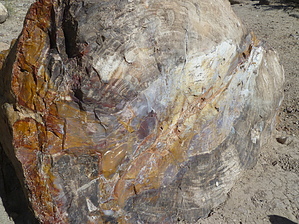
scared to death by kingsnake  Hike: It's short, so there is not really much to describe. Other than a petrified conifer, and some volcanic bombs, the Petrified Forest Trail does not have much to it. The really good stuff is on the Trail of Sleeping Rainbows, which is the way I will describe it. We'll go counter-clockwise. Make sure you bring your Nature Trail Guide so you can identify the numbered highlights.
When you reach the top of the plateau, at a half mile, you will have a great view south of Escalante and, in the far distance, the Kaiparowits Plateau. Two hundred yards further along are the first specimens of petrified wood, including what appears to be a nearly full trunk (though it is not intact). Not far past that is the beginning of the Trail of Sleeping Rainbows, with dire warning signs. Ignore them; continue on. The Trail of Sleeping Rainbows descends towards the edge of a small box canyon, then back up to rejoin the main trail only a few yards from where they split. This extension has more specimens than you can shake a (petrified) stick at. The most common colors are ochre, brick red and brown, with some grey. I did not see any green, blue, purple, etc. After the trails rejoin is small field of volcanic bombs, ejected from Boulder Mountain, which is 18 miles north. (And, post explosion, more of a plateau than a mountain.) Just before the loop closes is the park's prize attraction, a petrified conifer with identifiable rings. From there it's down the switchbacks back to the trailhead.
Check out the Official Route and Triplogs. Leave No Trace and +Add a Triplog after your hike to support this local community. One-Way Notice This hike is listed as One-Way. When hiking several trails on a single "hike", log it with a generic name that describes the hike. Then link the trails traveled, check out the example. | ||||||||||||||||||||||||||||||||||||||||||||||||||||||||||||||||||||||||||||||


