2019
This old undesignated trail is now the NW portion of the T-Bone Loop Trail. The description below was by the world-famous Sid when it was a use-trail dubbed Warrior.
Overview
Stats are to Star Peak 2,359. This trail is located in the Ma Ha Tauk range. To reach the base, one can go to 19th avenue and Dobbins Road and go south on 19th avenue to its southern end, where there is a large parking area.
Hike
Take a trail west and slightly south for about 200 meters. At this point, the Warrior trail takes a sharp left and heads steeply up a prominent ridge for about 1 mile to the summit of 'star peak'. The elevation gain is about 1000 feet. One can descend the same way, or follow an eastern ridge for 1.2 miles to the Ma Ha Tauk trail, and turn left and return to the trailhead. One can also turn right at Star peak, and in 0.5 miles, meet the Alta Trail. Either take the Alta Trail to the left and descend 1.5 miles to the San Juan road. or turn right and hike 3 miles to the Alta Trailhead at San Juan Point. For most people, the ascent up the warrior trail will take at least 25 minutes.
When hiking several trails on a single "hike", log it with a generic name that describes the hike. Then link the trails traveled, check out the example.
WARNING! Hiking and outdoor related sports can be dangerous. Be responsible and prepare for the trip. Study the area you are entering and plan accordingly. Dress for the current and unexpected weather changes. Take plenty of water. Never go alone. Make an itinerary with your plan(s), route(s), destination(s) and expected return time. Give your itinerary to trusted family and/or friends.
Permit $$
None
Directions
Road
Paved - Car Okay
To 19th Ave Trailhead From Phoenix, take 19th Ave south to where it dead-ends at the trailhead parking lot at the base of the mountain. The gate generally opens at 05:00 am. Do not leave valuables in your vehicle.
From PHX (I-10 & AZ-51) - 24 min (11.3 miles) From TUC (Jct 1-10 & Grant) - 1 hr 44 min (110 miles) From FLG (Jct I-17 & I-40) - 2 hr 14 min (148 miles)
 Route Editor

 Hau'Pal
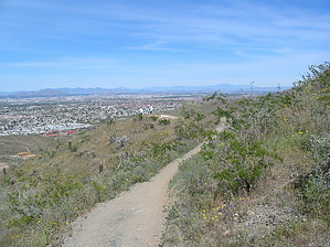


