Route Editor

| Guide | ♦ | 33 Triplogs | 2 Topics |
details | drive | permit | forecast | route |
stats |
photos | triplogs | topics | location |
| 254 | 33 | 2 |
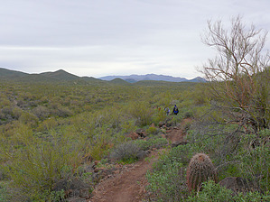
Desert Jambalaya by Dschur  Overview OverviewThe Black Canyon Trail is a trail in construction. It is a multi-use trail for bikes, horses, and hikers. It will be about 62 miles long, stretching from Carefree Hwy 74 to near Prescott. It follows along the bottom of the Bradshaw mountains. There are four trailheads now that connect 27.5 miles of trails. The trailheads are Emery Henderson Trailhead, Table Mesa Trailhead, Little Pan trailhead, and Black Canyon City Trailhead. There is access at the Carefree Hwy, but it isn't easy to get to, and not very good parking. The Emery Henderson Trailhead is the only trailhead at this time that is finished and has facilities. There are restrooms, paved parking, ramadas with picnic tables, grills, and horse rails. This is day-use-only parking, but with a permit from BLM, camping can be done. The Black Canyon Trail, when finished, will include ten trailheads conveniently spaced to allow easy access. History The trail's history is that it started as a prehistoric Native American trail and has been used since the 1600s for people and animals. In 1919, the Department of the Interior established the trail for livestock from the valley to the mountains. The Espil family took the last sheep on the southern end of the trail in 1974. North of Highway 69, it still is used. It was dedicated in 1969. In the Black Canyon Trail corridor has about 4000 acres. And 13.3 miles in Maricopa county segment was completed in 1992.
Hike The part I will describe now is the Boy Scout Loop via the Emery Henderson Trailhead. It starts at the north end of the parking lot. There is a sign-in box at the beginning of the trail. It is very well marked with both the Black Canyon Trail signs and signs that inform that it is a No Vehicle trail. It winds thru many types of desert forests. The trail crosses many roads along the way, but it is easy to find as you go along because of the trail markers. There are Cholla cactus forests, staghorn cactus forests, Creosote bushes, Barrel cactus forests, saguaro forests, and different bushes all along the way. Care should be taken in going off the trail in some areas due to the density of the Chollas. The first 4 miles or so are very flat and easy for most. The trail goes across a pipeline road, and there are a few areas that shooters go for "target practice" and has some trashy areas with everything imaginable shot up to smithereens. There is one little hill you climb the side of to get a lovely view of the desert to the west. You cross a few creeks that don't seem to run except after the heaviest of rains. The trail winds around and then ends up on a road that you follow for a while. Just keep to the road until you see the trail markers again. You then follow the trail up to a junction that is the Boy Scout Loop. It is about 4 miles to the loop from the trailhead. There is a sign at the intersection (it was lying against the trees at this time). You can take the loop either to the east or the west. I think the best is to the east first. The trail is being realigned as of this writing of the description and will be even better on the contours when finished, but most of the east side is redone. You will know when you get to the top of the loop and the side of a hill when you find the other Boy Scout loop trail sign. Then you can go on back to the trailhead or on down the trail farther. The next segment is the Doe Springs Section. If you come on back down the trail to the Emery Henderson Trailhead, follow the trail down, which changes to a road, then when you come to a junction, the only thing to know that you have the right trail is a little triangle sign on the east. It is hard to see, and the wording is faded. Follow this trail until you are back at the junction. There are also a few white-covered hills with quartz all around and prospect pits where they were checking out for minerals. This makes a nice loop for a day hike. The Loop itself is a little bit steeper and more rugged but makes a little bit of a challenge on an easy hike. With the loop included, it is about 11.5 miles. There was a notice about needing to check with BLM if overnight on the trail. Check out the Official Route and Triplogs. Leave No Trace and +Add a Triplog after your hike to support this local community. | ||||||||||||||||||||||||||||||||||||||||||||||||||||||||||||||||||||||||||||||||||||||||||||||||||||||||||||||||||||||||||||||||||||||||||||||||||||||||||||||||||||||||||||||||||||