Route Editor

| Guide | ♦ | 6 Triplogs | 0 Topics |
details | drive | no permit | forecast | route |
stats |
photos | triplogs | topics | location |
| 54 | 6 | 0 |
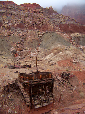
Old mine road to an old mine by PaleoRob   I am calling this trail Vermilion Cliffs Access Trail #6. It may have some other name, but it is not shown by any name on any map, nor do I know anyone else who has hiked it. I chose the name because it is the 6th crossing of the highway right-of-way leading into the Vermilion Cliffs National Monument after passing Marble Canyon. I am calling this trail Vermilion Cliffs Access Trail #6. It may have some other name, but it is not shown by any name on any map, nor do I know anyone else who has hiked it. I chose the name because it is the 6th crossing of the highway right-of-way leading into the Vermilion Cliffs National Monument after passing Marble Canyon.The trail begins at a dirt parking area where the old mining road departed from the highway. Before the area was declared a wilderness area, the road was open to the mine. Now, however, the trail follows the old roadbed. Park your car here and cross through the hiker's maze to enter the Paria Canyon-Vermilion Cliffs Wilderness.
The trail starts to get interesting after you reach the beginning of the foothills. The remains of an old gate can be seen on the south side of the road, and it is here that the trail starts to climb. You're now hiking over the Chinle Formation, which was laid down in the Triassic Period. This is the same formation that can be found in Petrified Forest National Park and is generally the dominating rock formation throughout the Painted Desert. The Shinarump Member of the Chinle is also known for its Uranium deposits. The road winds its way up through the lower portion of the Chinle and makes several switchbacks. In some places, the road is still well graveled, while in others it has been washed away. The switchbacks are broad, most likely to accommodate the mining trucks that used to ply this route. There are great views from along this route when the road curves along the east side of the hills. You can see the Echo Cliffs, Houserock Valley, and the Marble Bench, along with the dark chasm of Marble Canyon and the Kaiparowitz Plateau up in Utah. At the top of the Chinle, the road ends at an old mining operation. I don't have any data on what the mine produced, but based on its location, it is likely it was a Uranium mine. Use caution around this and all other mining areas; open holes are often unmarked. There are also some neat bits of rusted metal along the trail from the gate up to the mine. I find it interesting to guess what some of the odd bits may have been used for. If you are adventurous, you can use this as a stepping stone to further explore the eastern face of the Vermilion Cliffs and their foothills. If you are out for the day, however, you can return to your vehicle the way to came. Be sure to keep an eye out for petrified wood and Anasazi relics along the trail as well! They're there if you've got sharp eyes, but remember to leave them where you found them. Gate Policy: If a gate is closed upon arrival, leave it closed after you go through. If it is open, leave it open. Leaving a closed gate open may put cattle in danger. Closing an open gate may cut them off from water. Please be respectful, leave gates as found. The exception is signage on the gate directing you otherwise. Check out the Official Route and Triplogs. Leave No Trace and +Add a Triplog after your hike to support this local community. | ||||||||||||||||||||||||||||||||||||||||||||||||||||||||||||||||||||||||||||||||||||||||