Route Editor

| Guide | ♦ | 30 Triplogs | 0 Topics |
details | drive | no permit | forecast | route |
stats |
photos | triplogs | topics | location |
| 255 | 30 | 0 |
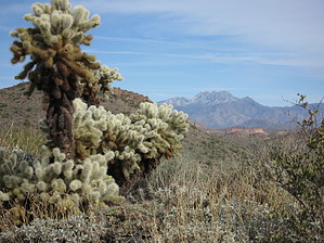
Unlock the treasure by AZLOT69  This loop can be accomplished in either direction. These directions and the flow of events are presented in a clockwise fashion. This loop can be accomplished in either direction. These directions and the flow of events are presented in a clockwise fashion.From the trailhead marked "Bulldog Canyon Off Road Area", begin your hike by crossing the gate and walking on the road, which is called Packsaddle Road at this point. Ahead lies the remains of an old stone quarry. The road curves left. Stay on the road. A little over one-third of a mile from the gate, the road starts to curve right at the gravel pit's southwest corner. On your left is an old jeep road with a brown forest service sign which says "Area Closed", this pertains to motor vehicles and is your trail. Follow this jeep trail to the left, then bear right at the first junction. Now heading northwest, you will almost immediately notice some old mining ruins on your left. This is part of the old Goldfield mining district. Take a look at the old concrete and steel remains, and as you look beyond, you will notice tailings from mining activity. If you have the time, you can meander around and find a few mines in this area. Be cautious and don't enter as they can be dangerous.
About 100 feet northwest of the mining ruins on the jeep road going towards peak 2297 is a large cairn on your left. Take this trail. In another 100 feet, bear right in the wash. Watch for cairns moving through the wash. This area has been spared from some recent wildfires, and sports mature vegetation. Very quickly, there is no sign of civilization, and other than the occasional mine whistle from the Goldfield ghost town, you feel miles away from anything. There are several paths, but stay on what should be the obvious main path and note peak 2297 on your right. When you come to a large wash, bear right in the wash. A short time later, you will see a large cairn on your right. Bear right on this trail. You will be in and out of small washes as your defined trail continues. The trail takes a steady climb heading towards the saddle ahead. At the saddle, there is an intersection. To the right is the shorter loop. To the left, the longer loop can be completed by bearing right at each subsequent intersection. From the saddle, taking the shorter loop to the right will start a descent. While rocky and steep in sections, take your time and look to your right. You will note an unusual rock outcropping referred to as the Green Thumb. To the right of the Green Thumb on the opposite side of the wash is another rock outcropping which houses Keyhole Arch, which can clearly be seen now. Your descent continues into a wash and out up to another trail. Turn right and follow to a slick rock wash at the bottom of the hill. You have lost sight of Keyhole Arch, but it is in the rock outcropping above you to the right. From this slick rock wash, you will note a family of four saguaros. This will be your be approach if you wish to go up and visit, perhaps crawl through Keyhole Arch. This is a bushwhack, be aware of snakes. Return to the trail or stay in the slick rock wash and head towards the Green Thumb. The trail passes left, and the wash passes right of the Green Thumb. Both come out to a jeep road at the northwest corner of the original gravel pit. Peak 2297 is still on your right as you walk Packsaddle road back to the trailhead. Gate Policy: If a gate is closed upon arrival, leave it closed after you go through. If it is open, leave it open. Leaving a closed gate open may put cattle in danger. Closing an open gate may cut them off from water. Please be respectful, leave gates as found. The exception is signage on the gate directing you otherwise. Check out the Official Route and Triplogs. Leave No Trace and +Add a Triplog after your hike to support this local community. | ||||||||||||||||||||||||||||||||||||||||||||||||||||||||||||||||||||||||||||||||||||||||||||||||||||||||||||||||||||||||||||||||||||||||||||||||||||||||||||||||||||||||||||||||||||||