| Guide | ♦ | 54 Triplogs | 1 Topic |
details | drive | permit | forecast | route |
stats |
photos | triplogs | topic | location |
| 331 | 54 | 1 |
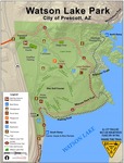
elementary my dear by HAZ_Hikebot  Overview OverviewWonder around the area and take in the world-class views. HAZ recommends taking the North Shore Trail to the dam and back for a 1.4 mi hike. For best results use our Official Route. A file mile hike around the lake is spectacular all around.
Day at the Lake My boyfriend and I love this area. We took two children with us to Watson Lake near the Granite Dells. Now, the actual Granite Dells location is somewhere else, but this particular sight is incredible. So incredible that a national geographic photographer was taking pictures of Watson Lake. Well, to make the story complete, there is ample space to wander about freely. Within Watson Lake, there is an area for unloading your boat. To the left is a side trail that you can take around the lake to the Dam. There is a pass through the dam that takes you to the other side of the lake and beyond. However, my boyfriend and I only climbed about a mile and a half with the kids I babysat. It's easy enough for a 4-year-old to handle if you stay on the trail. The scenery is excellent and breathtaking. There are places where we have seen people climbing a flat wall. There are primarily boulders the size of a Suburban and some so big that they could fit about three elephants into them. The cliff faces are pretty spectacular. It's recommended that you come in and out on the same day. We went in for an hour and a half. Taking anyway that seemed fun. Then found the trail back, which took us thirty minutes. The lake itself can be used for canoeing and kayaking. There is no wake, so the water stays absolutely still. There are plenty of places for the family to go in the park, including the playground and the smaller Granite areas to the right of the boat port. The hike can be moderate to difficult. If you stay on the trail, it is easy. If you stray and explore, it isn't easy. It is recommended that you take a compass because you could easily get lost in the vast area. This is one of my favorite places so far in Arizona besides the Canyon. For these Southern Eyes, it's truly a spectacular area to visit. There is overnight camping for a fee. Check out the Official Route and Triplogs. Leave No Trace and +Add a Triplog after your hike to support this local community. | ||||||||||||||||||||||||||||||||||||||||||||||||||||||||||||||||||||||||||||||||||||||||||||||||||||||||||||||||||||||||||||||||||||||||||||||||||||||||||||||||||||||||||||||||||||||||||||
 Route Editor


