| Guide | ♦ | 5 Triplogs | 1 Topic |
details | drive | no permit | forecast | 🔥 route |
stats |
photos | triplogs | topic | location |
| 54 | 5 | 1 |
NM's version of Humphreys from the Inner Basin by ddgrunning This is the "Humphreys-from-Inner-Basin" hike of New Mexico, albeit with a little less AEG and a little less impressive aspen groves, but with the added bonuses of multiple streams and summit views down to a nice, alpine lake. Lucky for me, my travels to Santa Fe allowed me to catch the area in peak fall colors season. Hike The approach to Santa Fe Baldy begins at the Santa Fe ski resort parking area, which sits at 10,300 ft. There is ample parking (no fee) next to the TH, which is furnished with bathroom facilities, but no water.
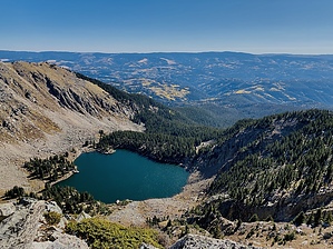
At that point, the trail heads in a more northerly direction and begins switchbacking--at first gently, and then more steeply, up to the Santa Fe Baldy saddle. What has been to this point a mostly forested hike, opens up to views of the surrounding peak, as you approach and then cross the tree line. As it was a cold but clear mid-October day on my hike, this was also the first time the sun shed some warming rays on me, unfiltered by the thick forest. At the saddle, which lies at about 11,700 feet, the warmth of the sun was blunted by the countervailing wind, which picked up and prompted a short break to layer up a bit. More interestingly, the saddle provides your first glimpse of the other side of the divide, which on this day, painted a picture of fall colors in the forested hills and valleys beyond. At this junction--nearly 6 miles in, the Winsor trail continues down the other side of the divide down towards Katherine Lake (not visible from the saddle). That's a trip for another day, though you can look forward to seeing Katherine Lake from just beyond the summit a little later on. Leaving the trusty Winsor trail, at the saddle, the destination on this day is Santa Fe Baldy, the trail to which hangs a hard left at the saddle, and much like its Humphreys counterpart in AZ, leaves a steep mile and another 900+ feet of AEG to make the summit. The trail up to this point is well groomed and easy to follow. Just past the saddle, the trail enters a rocky area, which makes the trail somewhat more difficult to discern in spots, but nothing that requires significant route finding skills. Now fully above the treeline, the views get more and more expansive as you ascend. From the saddle on up, it's likely to be a little windy. On this day, it was (thankfully) not much more than a breeze--though still quite cold, with short stints of photo-opping followed quickly with shoving my hands back into my pockets to re-warm them. The trail generally follows the divide up and around to the north until the summit cairn comes into view. The cairn provided welcome shelter from the easterly blowing winds. For some reason, my Garmin registered the summit at 12,660, rather than 12,622. Venturing beyond (and yes, down) from the summit means some additional AEG to get back to the trail, but is well worth it for the "money shot" of the hike with beautiful views down to Katherine Lake, nearly 1000 feet below. Lots of good spots to sit down, enjoy the sun and the break from the wind, and soak in the beauties of nature surrounding you in this alpine environment. On this day, I crossed paths with only one person on the entire trip up, and enjoyed complete solitude at the summit. After a good 20 minutes exploring the summit/Lake Katherine views, I returned the way I came. Those last couple of miles going back UP to the wilderness boundary--though gently rising, were more taxing on my "ascenders" than I wanted. The steep descent over the last 3/4 mile brought me back to the parking area, followed by a winding and beautiful canyon drive, during which the best fall colors were on proud display from about 8000-9500 ft.--with the roadsides swelling with carloads of visitors, getting their fall color fix in. Gate Policy: If a gate is closed upon arrival, leave it closed after you go through. If it is open, leave it open. Leaving a closed gate open may put cattle in danger. Closing an open gate may cut them off from water. Please be respectful, leave gates as found. The exception is signage on the gate directing you otherwise. Check out the Official Route and Triplogs. Note This is a moderately difficult hike. Leave No Trace and +Add a Triplog after your hike to support this local community. | |||||||||||||||||||||||||||||||||||||||||||||||||||||||||||||||||||||||||||||||||||||||||||||||||||||||
 Route Editor


