Route Editor

| Guide | ♦ | 15 Triplogs | 0 Topics |
details | drive | no permit | forecast | route |
stats |
photos | triplogs | topics | location |
| 190 | 15 | 0 |
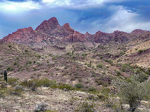
Give me a sign! by John10s  Overview OverviewThis is an out-and-back hike of ~six miles to the 2,182' summit of Signal Mountain, the namesake mountain in the Signal Mountain Wilderness that covers a portion of the Gila Bend Mountains southwest of Phoenix. Despite the relatively modest distance and AEG for the hike, a steep, scree-covered approach to the summit block and a class-three scramble to the top add to the challenge and excitement. Hike Signal Mountain is visible from the parking area along Woolsey Wash. Start heading west/northwest directly toward the peak, passing to the south of a dark volcanic cone. The early part of the hike consists of flat, easy desert hiking through sparse vegetation, crossing a few small washes, and gaining only ~300' of elevation over the first two miles.
Continue up a short, steep stretch to the base of the summit block, then follow it to the south, navigating through some palo verde and brush. The terrain remains rocky, but footing improves with a brief stretch of flatter ground and less scree along this stretch. On the southeast side of the summit block, begin the final, steep class-three scramble to the top. Several sections with loose rock require careful steps, but there isn't any serious exposure on that final climb, and you'll soon level off on the narrow, rocky ridgeline with the summit just ahead. As of this writing, there's a summit register on top dates back to the early 2000s and contains a surprising number of out-of-state entries for a relatively seldom-visited wilderness area. You'll also find remnants of metal cables, deteriorated wooden telephone poles, and four metal braces that once supported a structure of some kind. The summit offers unobstructed 360° views of the surrounding area; to the southeast, Woolsey Peak is the dominant landmark, and Bunyan Peak is visible farther to the south. Looking north/northwest, landmarks include the Eagletails, Saddle Mountain, the Harquahalas, with the railroad tracks in the foreground where the 1995 Palo Verde derailment occurred. Once you're ready to leave the peak, you can return to the parking area via the same route. If you're ready for more hiking, consider a short drive and a hike up to Woolsey Peak, which is less than five miles from Signal Mountain. Triplogs also include write-ups of several Signal Mountain routes that don't go up to the summit but take you to scenic areas in the nearby wilderness, including some arches and caves. Check out the Official Route and Triplogs. Leave No Trace and +Add a Triplog after your hike to support this local community. | |||||||||||||||||||||||||||||||||||||||||||||||||||||||||||||||||||||||||||||||||||||