History
King S. Woolsey also has a point & butte named after him in Grand Canyon. This well-known settler had a ranch and station in the Gila Bend area. He led volunteer troops along with Alsop and Montgomery in defeating natives in the battle of Bloody Basin.
Hike
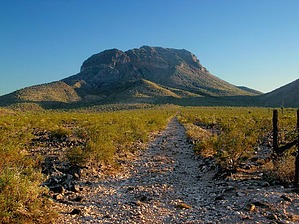
This hike is so desolate and lonely that the bighorn sheep we ran into were not afraid of us. Not many people attempt this hike. There is no trail to the summit. Armed only with a terrible fax from BLM that functioned as our 'map' that showed little or no information, we got completely lost. I mean, it would be nearly impossible to find a worse route to the summit.
We followed the road at the base of the mountain as far as it went... and then just scrambled up the north side of the mountain through an impossible landscape of large, black boulders. The top of the mountain, which is relatively flat, is a field of incredibly close-packed jumping Chollas. While we were picking our way slowly through this forest of pain, we heard the approach of a swarm of bees. Well, do you run for it and impale yourself on six thousand jumping Chollas or wait and die of bee stings? We opted for the latter death and were pleasantly surprised when the bees flew a few feet over our heads and left. Do not attempt this peak from the north face. It was five hours of sheer hell. Once on top, it became clear from reading the peak diary that other climbers had gotten up relatively quickly and easily from the eastern face. We decided to descend the east face, and, except for one rattlesnake and one 30-foot drop off around which we had to scale on a foot-wide ledge with no rope, things went pretty smoothly. The hike is basically all boulders... and you get pretty damn sick of them. All in all, though, it is a truly rugged and wild place that any hard-core Sonoran desert hiker will love. DO NOT attempt this hike in the summer.
WARNING! Hiking and outdoor related sports can be dangerous. Be responsible and prepare for the trip. Study the area you are entering and plan accordingly. Dress for the current and unexpected weather changes. Take plenty of water. Never go alone. Make an itinerary with your plan(s), route(s), destination(s) and expected return time. Give your itinerary to trusted family and/or friends.
Permit $$
None
Directions
Road
High Clearance possible when dry
To hike From the town of Hassayampa head south on US 80 for 8 miles. Go west on Agua Caliente Road approximately 5 miles to an unnamed road forking to the left. Take this road another 5 miles to the wilderness boundary.
As a graded dirt road, Agua Caliente Rd veers off to the right from the paved surface, approximately 1/2 mile from old US 80, and shortly before a gate at a cattle grate. The gate may be locked.
 Route Editor

 History