 Route Editor

| Guide | ♦ | 69 Triplogs | 1 Topic |
details | drive | permit | forecast | route |
stats |
photos | triplogs | topic | location |
| 1k | 69 | 1 |
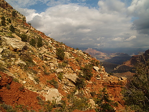
Skirtin' Tavertine on the Esplanade by HAZ_Hikebot   History HistoryThe Boucher Trail (pronounced Boo-shay) offers access to a charming and secluded part of the Grand Canyon, but the beauty has a price. The Boucher challenges even experienced canyon hikers. The trail consists of tough, tedious traverses linked together by knee-destroying descents, with a section of exposed hand and toe climbing thrown in for good measure. On the other hand, the canyon always seems to compensate physical effort with spiritual rewards, and opportunities abound to explore side canyons, encounter wildlife, examine ancient geology, and touch the Colorado River at the bottom of the Grand Canyon. The Boucher Trail was the creation of Louis D. Boucher, the "hermit" of the Hermit Creek basin. Boucher maintained seasonal residences at Dripping Spring and near Boucher Creek and lived in the area for 20 years. Labeled a hermit because he lived alone, Boucher was well known and socially active within the South Rim community during the latter part of the 19th century. Boucher called his trail the "Silver Bell". Very few modern hikers follow the original Silver Bell Trail from the rim above Dripping Spring. Most of the old switchbacks are intact, but the location of the trailhead is an obscure spot no longer accessible by vehicle. For all practical purposes, the Boucher Trail, as we know it today, starts at the intersection below Dripping Spring.
Hike the Hermit Trail two miles through the Kaibab, Toroweap, and Coconino Formations to the Dripping Springs Trail junction. Turn west (left) and follow the narrow Dripping Springs Trail for 1 mile as it rounds the bays at the head of the Hermit Drainage before intersecting the Boucher Trail proper. Striking views of the often overlooked Esplanade Sandstone which is the topmost member of the Supai Group are visible and quite impressive in this area. The Boucher Trail departs in a northerly direction continuing the long traverse on the rim of the esplanade. The route crosses numerous small, steep drainages complicated by rockslides from the Coconino cliff above. Finally, the spectacular camp below Yuma Point is reached. This indeed is one of the finest upper canyon camps with soaring openness and classic seasonal "Esplanade water pots." Fair warning that this area is directly below the Dragon Flight Corridor which can mean a sometimes constant sound of helicopter noise. In the summer a generous flight curfew of two hours at dawn and dusk will allow a well-planned hike to be thoroughly immersed in silence. In essence, a hiker could pull into camp late in the day and pack up and move out early the next day and never hear the whump-thump of the tour flights. The trail continues on the flat Esplanade as it rounds the corner below Yuma Point into the head of Travertine Canyon. Continue at this level for perhaps half a mile, then start looking for where the route drops abruptly down the slope toward the bed of Travertine Canyon. A break in the upper cliff requires intimidating hand and toe climbing, and it is tough going throughout the Supai. The trail is being slowly reclaimed by erosion - steep, narrow, and covered in a layer of ball-bearing-like pebbles. Take your time! The route drops to the Redwall rim of Travertine Canyon crosses to the west side of the drainage and wanders across the open saddle between Cocopa Point and Whites Butte to the top of a gully that plummets through the Redwall Limestone southwest of Whites Butte. The descent to the Tonto Trail is nothing less than brutal, a physical beating in classic Grand Canyon style. The Tonto Trail intersection is marked by a large cairn (no sign). Go right (north and east) along the Tonto Platform toward Hermit Creek or turn left (west) and continue down through the Tapeats Sandstone to Boucher Creek and permanent water. If time allows it is an easy walk down the creek to the Colorado River. The Tonto Trail could be used to complete a loop hike from Hermits Rest down the Boucher Trail and up the Hermit Trail (or vice-versa). It is about five waterless miles between Boucher and Hermit Creeks, and the trail is well defined. Great canyon views and spectacular travertine deposits near the bed of Travertine Canyon provide diversion en route. Water Sources The only reliable water along the Boucher Trail is Boucher Creek and the Colorado River. The Colorado River is often sediment-laden and may be difficult to purify. Water may be available at Santa Maria or Dripping Spring, but neither is considered permanent and both involve considerable detours away from the Boucher Trail. Potholes at the top of the Supai north of Yuma Point may hold water for a few days after precipitation, but dry up quickly and are often frozen solid in winter. Campsites The Boucher Trail is contained within the "at-large" use area BN9. Nice (but dry) sites can be found where the trail rounds below Yuma Point and on the saddle just south of Whites Butte. Camping near water is possible along Boucher Creek near the Tonto Trail crossing and at the Colorado River. Camping in the Hermit Creek Use Area is restricted to the designated campsites at Hermit Creek (BM7) or Hermit Rapids (BM8). Please Note The Boucher Trail is arguably the most difficult and demanding of the south side trails. The overall condition of the trail, especially in the Supai and Redwall Formations, presents an obvious hazard. The trail through the Supai is hard to follow when covered with fresh snow. Map reading skills are essential. The Boucher Trail is best left to highly experienced canyon hikers.
Check out the Official Route and Triplogs. Leave No Trace and +Add a Triplog after your hike to support this local community. One-Way Notice This hike is listed as One-Way. When hiking several trails on a single "hike", log it with a generic name that describes the hike. Then link the trails traveled, check out the example. | |||||||||||||||||||||||||||||||||||||||||||||||||||||||||||||||||||||||||||||||||||||||||||||||||||||||||||||||||||||||||||||||||||||||||||||||||||||||||||||||||||||||||||||||||||||||||


