 Route Editor

| Guide | ♦ | 7 Triplogs | 0 Topics |
details | drive | permit | forecast | route |
stats |
photos | triplogs | topics | location |
| 237 | 7 | 0 |
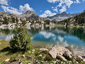
Zero to Sixty by chumley Sixty Lake Basin lies about two miles west and a couple of hundred feet higher than the immensely popular and stunningly beautiful Rae Lakes basin, separated by a ridge that divides the two basins and is dominated by Fin Dome. Sixty is a worthy day hike for backpackers spending two nights in the Rae Lakes area and offers far less-visited camping options than the Rae Lakes. Hike The trail to Sixty Lake Basin begins at a signed junction along the PCT/JMT a few yards south of the crossing between Upper and Middle Rae Lake. From this point, the initial half mile heads north along the western shore of Middle Rae Lake before beginning a mile-long 600-foot climb to a small, unnamed lake at 11,200 feet. The views along this mile, looking back down to the Rae Lakes and up to Glen Pass and the rugged peaks along the crest are as good as any in all of the Sierra Nevada.
Next, the trail drops about 200 feet while crossing a drainage with a picturesque creek running from one of the upper lakes down to a lower lake. As the trail rounds a corner to the west, another of the beautiful, unnamed 60 lakes comes into view to the north, about a quarter mile away and 200 feet below the trail. At the 2.5 to 3-mile mark of the hike, the trail reaches the heart of Sixty Lake Basin. At this point, the route becomes less defined as hikers spread out and explore the two large lakes to the south and southwest. I would recommend making this area your destination and turn-around point if a ~6-mile day hike is in your wheelhouse. If you want more miles and exploration, the most defined route continues north from this area for more than half a mile. As it continues, it becomes less defined and more difficult to follow. No matter, there's no wrong way to go, and there are few impediments to travel. Any obstacle can be easily navigated around, whether it is a small body of water or a granite outcrop. An unofficial route veers off near the end of this track and heads down to Arrowhead Lake, making for a possible loop hike. Most hikers choose their preferred mileage and return the way they came whenever they feel like they've gone far enough. Camping For those who seek more solitude on their wilderness backpacking trips, Sixty Lake Basin provides ample opportunities for camping far from the bustle of the Rae Lakes. It's an extra couple of miles and 700 feet more elevation, but some may find the extra work to provide a worthwhile return on investment. Check out the Official Route and Triplogs. Leave No Trace and +Add a Triplog after your hike to support this local community. One-Way Notice This hike is listed as One-Way. When hiking several trails on a single "hike", log it with a generic name that describes the hike. Then link the trails traveled, check out the example. | |||||||||||||||||||||||||||||||||||||||||||||||||||||||||||||||||||||||||||||||||||||||||||||||||||||||||||||||||||||||||||||||||||||||||||||||||||||||||||||||||||||||||||||||||||||||


