 Route Editor

| Guide | ♦ | 33 Triplogs | 1 Topic |
details | drive | permit | forecast | 🔥 route |
stats |
photos | triplogs | topic | location |
| 578 | 33 | 1 |
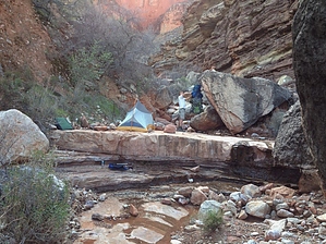
Long Rugged West by HAZ_Hikebot   Overview OverviewAs canyon hikers gain experience many seek to broaden their wilderness horizons and inevitably thoughts turn to the Tonto Trail west from Boucher Creek to the South Bass Trail. This segment of the Tonto Trail is notorious, regarded by canyon experts as the most difficult and potentially dangerous section of this long transcanyon trail system. Main reason: It is almost 30 rough, unmaintained miles from the permanent water in Boucher Creek to the South Bass trailhead, and throughout that entire stretch there are no reliable water sources near the Tonto Platform level. None. Another thing: Once started, hikers are committed. The complete lack of bail-out routes to the rim between Boucher and Bass means the only possibility for help is at the end of the trek. Combine these factors with the usual selection of Tonto Trail hazards (such as narrow, eroding trails, numerous passages near the brink of sizable cliffs, and a notable lack of shade) and it all adds up to a serious undertaking. Hike Follow Boucher Creek down to the confluence with Topaz Canyon and look for where the trail climbs the slope west of the drainage bottom. Climb the trail to the top of the Tapeats Formation and start around Marsh Butte, headed for Slate Creek.
Note The Tonto Platform provides the only convenient route between the side canyons for almost 40 river miles but it falls far short of traversing the entire length of Grand Canyon. West of the Bass Trail the Tonto Trail starts pinching down until it disappears entirely at Garnet Canyon. West of Aztec Amphitheater the Esplanade, a new platform system at the top of the Supai Formation, becomes the main playing field for transcanyon walkers. Water Sources As previously stated, drinking water is an essential issue along the western Tonto Trail. There are no permanent springs, only unreliable, unpredictable, seasonal trickles here and there. Sometimes it's there, sometimes it's not. The Backcountry Information Center occasionally receives and files water reports from hikers or patrol rangers, but the utility of these reports is limited because what was there two weeks ago might not be there today. The only way to obtain accurate water information before departing is to talk with someone who walked the route very recently, but that is easier said than done. Under these circumstances, hikers have no choice but to assume the worst. It is the responsibility of the trip leader to always have a backup plan if anticipated water sources come up dry. The most critical step you can take to protect yourself and your group are: Schedule your hike for the cool months, November through April. This is when water is most likely to be found in the side canyons, and cool weather means hikers can cover the ground most efficiently. Secondly, get water when you can! Fill your water containers, and your belly, every chance you get. Heavy water loads and dry camps are almost inevitable. Water records indicate (predictably) that the best chance for water occurs during cool weather in the larger drainages, Ruby, Turquoise, Sapphire, and Slate. Water is sometimes found above or below Tonto Trail level but you will have to decide if it is worth the time and effort to check. There is relatively easy access to the Colorado River at the bottom of the Bass Trail and via the beds of Serpentine Canyon and the unnamed side canyon east of Serpentine. There are rugged scrambles to the shoreline from the rim of the Inner Gorge west of Turquoise and via the drainage bottom in Ruby and Slate, but all routes to the River are major detours off the Tonto Trail and the latter three require well-developed climbing and route-finding skills. Campsites The Tonto Trail between Boucher Creek and the South Bass Trail is contained within "at-large" use areas BN9, BO9, BP9, and BQ9. Decent sites can usually be found where the trail crosses the side canyons and occasionally near the trail between the drainages. As usual, hikers are requested to utilize established sites to minimize the impact on a pristine part of the canyon. Segments to Consider:
Check out the Official Route and Triplogs. Leave No Trace and +Add a Triplog after your hike to support this local community. One-Way Notice This hike is listed as One-Way. When hiking several trails on a single "hike", log it with a generic name that describes the hike. Then link the trails traveled, check out the example. | |||||||||||||||||||||||||||||||||||||||||||||||||||||||||||||||||||||||||||||||||||||||||||||||||||||||||||||||||||||||||||||||||||||||||||||||||||||||||||||||||||||||||||||||||||||||||||||||||||||||||||||||||||||||||||||||||||||||||||||||||


