Route Editor

| Guide | ♦ | 8 Triplogs | 3 Topics |
details | drive | no permit | forecast | 🔥 route |
stats |
photos | triplogs | topics | location |
| 106 | 8 | 3 |
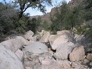
Canyons are inherently risky. Flash floods occur without notice on sunny days. Technical skills & surrounding topography knowledge required yet does not eliminate risk.
There was really a trail here once? by Fritzski  2026 March Changes 2026 March ChangesThe Carney Spring Trailhead is closed. This hike now begins at the Lost Goldmine TH. It is 0.5 mile longer one-way and 16 feet less AEG. Warning: No trail in sections I would recommend this trail (or lack thereof) to that masochistic someone looking for a challenge that has exhausted almost everything else on his/her list. I say this because although your ultimate goal, Willow Springs, may be really neat (I wouldn't know, I didn't make it), getting there is a bear, to say the least. In other words, unless Willow Springs is incredible, the coolness/effort factor was low. Although getting lost is a distinct possibility and taking careful note of landmarks along the way is recommended, the real reason I would rate this hike so difficult is simply the complete lack of any discernible trail and the completely overgrown vegetation. If, as the old Geographic Survey topos indicate that there was a trail here, it has long since disappeared. My guess is that if there was once an established camp at Willow Spring, they accessed it mainly from the North out of the Massacre Grounds area. The trail starts at West Boulder Saddle out of Carney Springs Trailhead (see Dacite Super Loop). From the saddle, I just basically continued straight ahead right down into the stream bed and followed it downstream (left) from there. Although workable, this approach caused much "head-scratching" and some reasonably heavy-duty bouldering. Believe it or not, there are cairns to be seen. Basically, when the route was obvious, they were aplenty, but always had a way of disappearing when you needed them. I'm generous when I say that every so often, a hint of what once was a trail would appear, only to beg the question of whoever else was insane enough to be down in this jungle. Following my arduous but straightforward stream bed strategy (virtually all of it at varying heights above the right bank), I made it about 3/4 of the way to Willow Springs by my estimation (3.5 Hrs). Had time not been a factor, I probably could've inched my way further along, but there were no signs of things easing up at all. On my return, I learned of several improvements to my original route. #1 From W.Boulder Saddle, don't go straight down into the creek basin. Instead, follow the Ridgeline trail to the West (left) for about a quarter-mile. You will see several cairns with one down and to the right of the trail. This should line up with a large dead tree down in the creek bed. Head down at that point. #2 To avoid some radical bouldering, when you get to the point where you can see the creek starts to head around a corner to the North (right), instead of following it, climb the ridge above and to your right, go over it and down into another smaller creek bed. Follow that one until it merges and continues. If I ever get desperate, wondering what treasures lie at Willow Springs, I may someday try it again. I wish somebody else would do it first with a machete. It would be somewhat more manageable if the creek bed were dry, although not a free pass by any means. Unfortunately, this creek does not lend itself to boulder hopping, as do some others. My concern about going when it was dry would be the heat. I went on a cool day, and it was still a bit close down in there. So there you are. I'm sure everybody's all excited to go, but I didn't want to pull any punches either. If anyone has done or does this hike to Willow Springs, I would personally invite them to email me so I can first congratulate them and next find out what's back in there. Check out the Official Route and Triplogs. Leave No Trace and +Add a Triplog after your canyon trip to support this local community. | ||||||||||||||||||||||||||||||||||||||||||||||||||||||||||||||||||||||||||||||||||||||||||||||||||||||||||||||||||||