Route Editor

| Guide | ♦ | 6 Triplogs | 2 Topics |
details | drive | permit | forecast | route |
stats |
photos | triplogs | topics | location |
| 0 | 6 | 2 |
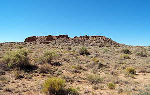
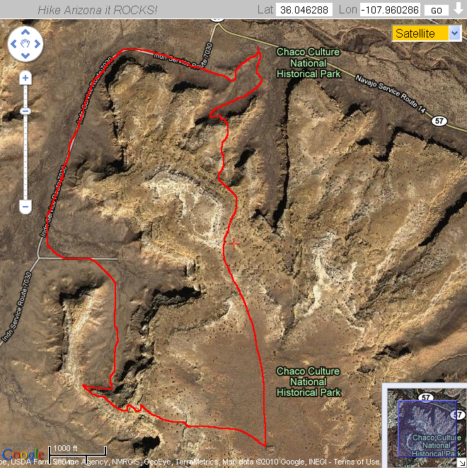
Journey to Black Wood. by PaleoRob  Warning: There is no water or shade for the entire route. Start early, especially during the summer months, and make sure that you have more than enough water to complete the hike.
Hike: The South Mesa trail begins at the Casa Rinconada parking lot. For the first short while you will be following the Casa Rinconada trail around some of the Hosta Butte BC sites. Once you reach stop 10 on the Casa Rinconada trail, though, the South Mesa trail diverges. This divergence is signed. It starts out with a gradual climb to a sandstone bench above the canyon bottom. While the views of the canyon from this point are good, continuing up the trail a short distance further brings you to a crack. The trail goes up the crack - it is short and easy to ascend. At the top of the crack there is a broad slickrock apron which affords the best views of Chaco Canyon along the entire trail. Take a moment to soak up the view. When you have rested and seen what you wanted, follow the cairns as the trail resumes its slow, gradual climb up the mesa. The trail will eventually rise 400 feet above the parking area, but the angle of ascent, except for in the crack, is never terribly steep. When you reach the top of the mesa, Tsin Kletzin is not immediately visible. The trail is obvious, however, as a sandy slash through the vegetation. You will climb a series of low stabilized dunes and Tsin Kletzin will come into view as a low hump with the remains of walls rising from the sand. There is a sign at the ruin announcing that you have arrived and another listing mileages back to the parking lot either via the cliff trail or the South Gap. Before continuing, though, take a moment to explore Tsin Kletzin. There are several standing walls, historic inscriptions, and kivas. Nearby is the famous Weritos Rincon dam, a large masonry dam that backed storm water up in Weritos Rincon. Access to the dam is difficult and generally frowned upon by the Park Service (it requires going "off trail"). After poking around the ruins, return to the trail junction and follow the western branch towards the South Gap. The trail begins slowly descending the sandy mesa top until it comes to a sandstone ledge. This ledge provides decent views south out of South Gap, but by descending the trail further to a spur ridge there are even more impressive views. There is a prehistoric road alignment in the South Gap, but it is extremely difficult to make out. The trail switchbacks down into a side canyon that leads into South Gap. There are views of coal deposits, and the trail passes a few unexcavated ruins, but this section of the trail is very different from the mesa-top section as you are in a confined canyon. Eventually the trail leads to South Gap proper, and the remainder of the trail is on a Park Service access road that parallels the old South Road that led out of Chaco Canyon towards Kin Ya'a. This road can be barely discerned to the west of the modern road, but only in certain places. The road bends east and you are back in Chaco Canyon proper. There are two important prehistoric structures near the bend, South Gap Road House and South Gap Herradura, but it takes a trained eye to spot these. At this point the trail is alternating between being on top of and paralleling the old Chacoan road that led west from Casa Rinconada to South Gap. The trail climbs the mound below Casa Rinconada and rejoins the Casa Rinconada trail at that point. Returning to your vehicle is as easy as walking down the slope to the parking lot.
Check out the Official Route and Triplogs. Leave No Trace and +Add a Triplog after your hike to support this local community. | |||||||||||||||||||||||||||||||||||||||||||||||||||||||||||||||||||||||||||||||||||||||||||||||||||||||||||||||||||||||||||||||||||||||||||||||||||