 Route Editor

| Guide | ♦ | 21 Triplogs | 0 Topics |
details | drive | permit | forecast | 🔥 route |
stats |
photos | triplogs | topics | location |
| 44 | 21 | 0 |
All the Cactus Forest sights, less confusion! by Jeffshadows  The Cactus Forest is the aptly named frontal section of the Rincon Mountains falling within Saguaro National Park, East. Standing on any hilltop in the area will give expansive views of saguaro growing in massive clusters similar to pine in a forest. One of the things that makes the area so rewarding also makes it frustrating... there are over two dozen trails packed into the area, some as short as two-tenths of a mile. These trails frequently cross one another and many ultimately lead to the same destinations. As such, many are redundant and can be largely ignored unless one wishes to simply visit something new. Following this series of trails, which I'll call the "Garwood Dam Loop", will take a hiker past all of the major sites of significance in the Cactus Forest while offering sweeping, ever-changing views. The Loop will make a stop at Bridal Wreath Falls, then pass by three natural and one steel tank, and finally swing by Garwood Dam on its way back to the trailhead where it began. The trip can be made less strenuous by reversing the direction of travel. The Cactus Forest is the aptly named frontal section of the Rincon Mountains falling within Saguaro National Park, East. Standing on any hilltop in the area will give expansive views of saguaro growing in massive clusters similar to pine in a forest. One of the things that makes the area so rewarding also makes it frustrating... there are over two dozen trails packed into the area, some as short as two-tenths of a mile. These trails frequently cross one another and many ultimately lead to the same destinations. As such, many are redundant and can be largely ignored unless one wishes to simply visit something new. Following this series of trails, which I'll call the "Garwood Dam Loop", will take a hiker past all of the major sites of significance in the Cactus Forest while offering sweeping, ever-changing views. The Loop will make a stop at Bridal Wreath Falls, then pass by three natural and one steel tank, and finally swing by Garwood Dam on its way back to the trailhead where it began. The trip can be made less strenuous by reversing the direction of travel.Some notes about hiking in Saguaro East: - The Cactus Forest is nearly completely exposed to the afternoon sun. Shade can be found but is not the norm on the trail. Water sources in the area are unreliable. Sun protection and extra water are a must. - Trails in the park are not signed in the same way they are by the Forest Service. The sign will display the name of the trail it is facing in large letters at the top, not the trail you are on, which is confusing and annoying. Pay close attention to the arrows on the signs to help you discern which way to go. The signage issue is aggravated by the number of intersecting and criss-crossing trails in the area. - Be aware that the first mile or so of the Douglas Spring trail is extremely heavily used. It is not unusual to arrive midday in the middle of the week and find the trailhead parking lot full. Persons of varying degrees of skill and questionable understanding of etiquette utilize the trails in this area heavily, principally because they are less rigorous than others in the valley. Plan accordingly. - Since this loop takes visitors through a National Park, observe the rules that differ from the forest or state land, including a ban on firearms and overnight camping without permit (Available at Visitor Center on Old Spanish Trail).
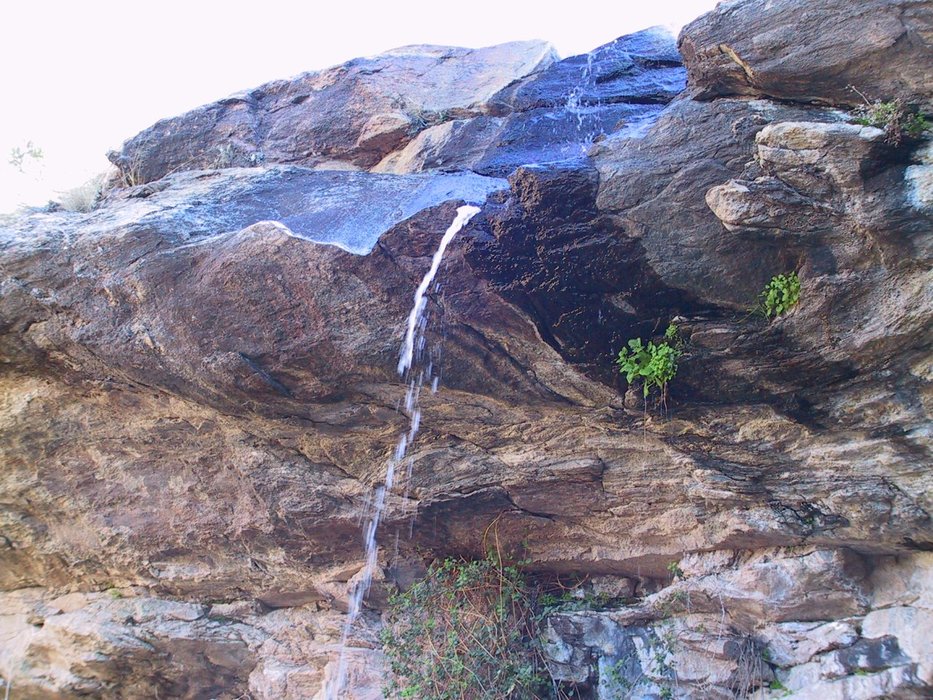
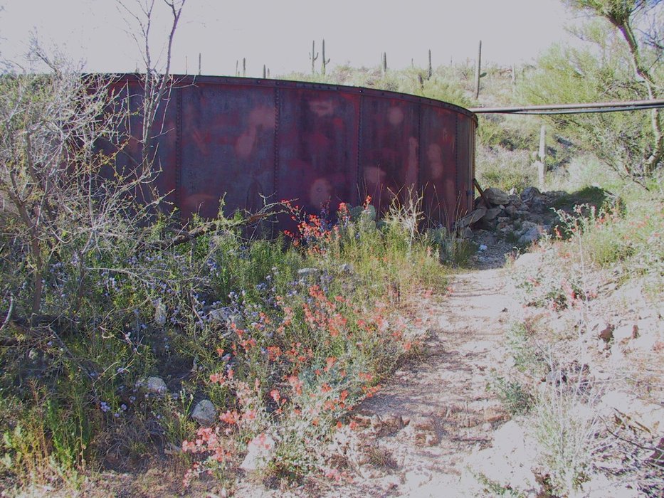
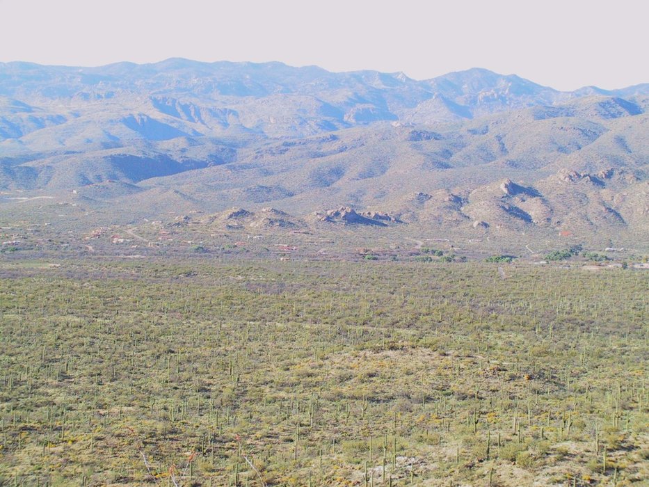
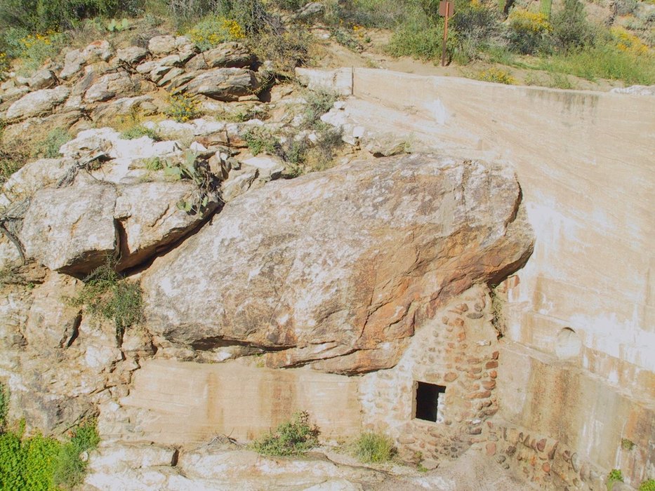
The loop begins at the Douglas Spring trailhead at the end of Speedway Blvd. Begin by following the Douglas Spring trail east as it starts to climb into the Rincon foothills. Don't forget to sign in to the register. After passing junctions with three other trails and covering about a mile, the trail begins to climb steadily. This part of the trail is a great place for trailside geology, and is usually studded with wildflowers when in season. After climbing for about a mile the trail passes through a grassy valley and reaches a junction with the Three Tank trail. Continue on the Douglas Spring trail. After winding through an ever increasingly riparian area the trail reaches a junction with the Bridal Wreath Falls trail. Turn South and follow this trail en route to Bridal Wreath falls. After winding through a shaded area for a bit, the trail rejoins the ridge line and passes by a hitching post for equestrians before dropping back into the stream. Climb the boulders for the final approach to the falls, which flow in the spring and fall, or after heavy rains. Bridal Wreath Falls. Leg 2 - Bridal Wreath Falls to Garwood Dam - 4.5 miles Return to the Douglas Spring trail and head in the direction opposite you just came until reaching the junction with Three Tank Trail. Turn south (left) and follow the Three Tank trail as it climbs over a short ridge. At the top of this first ridge look down and to the north (right) and you will see Aguila Tank, a natural tank in the bottom of the stream course. Aguila Tank was dry when I passed by in March. The trail continues winding its way over shot hills and through small valleys, frequently offering great panoramas of Tucson, the Catalinas, and views of Mt. Wrightson with awesome detail. After about a mile the trail passes close to the stream course once again and offers a view down into the canyon and Mica Tank. Mica Tank is a natural tank that was reinforced with a small wall which is now only slightly visible. It might be one of the few places where one can see saguaro growing right up to the banks of a small lake. The trail soon crosses the stream and climbs up and over another small ridge before arriving at a large steel reservoir known as Steel Tank. Steel tank is fed by pipes from Rock Spring, just to its east in the stream course. Steel Tank Pass under these pipes and by the tank to connect to the Carillo trail and continue on. Do not follow the trail leading alongside the stream, this is the continuation of the Three Tank trail. The Carillo trail continues west, losing elevation and offering great views as the Three Tank trail did before it. After about 1/2 mile the trail offers a view of the old aircraft landing strip located down near the Wentworth trail back near the trailhead. It is best appreciated from this vantage point. Garwood Airstrip The airstrip was used by the Garwood family. The trail loses elevation sharply, now, on its approach to the junction with the Wild Horse trail. At the junction, which is situated in a small valley, one can choose to hike the 1/2 mile south to the Little Wildhorse Tank, another natural tank that is well-worth a visit. It is large and usually swollen with water year-round. Return to the Carillo trail, or continue along the Carillo trail as it climbs over two small ridges and then begins a steep descent toward Garwood Dam, which should now be visible to the west. After climbing down the ridge the trail approaches Garwood Dam. The Dam provided a steady supply of water for Nelson Garwood and his ranch in the 1950's before the area was part of the National Park system. Garwood Dam The airstrip seen from the trail earlier was used by Garwood, and the Garwood trail, the final leg of the loop, was the trail Garwood used to move freight back and forth from the airstrip to his ranch. To one side and at the bottom of the dam is a small stone room built to house tools (beware of bees). Leg 3 - Garwood Dam to Trailhead - 2.0 miles After visiting the dam rejoin the Carillo trail and follow it just to the trail junction at the base of the hill above the dam. Turn right (north) at this junction onto the Garwood trail. In the area of the junction one can see the remains of old building foundations and a small clearing or two that used to be home to the Garwood Ranch. The Garwood trail heads north, losing elevation slightly, and passes numerous trail junctions along its path back to the Douglas Spring trailhead. One that is most confusing comes when the Bajada Vista trail bisects the Garwood trail about 1 mile from the dam. It will be necessary to follow the Bajada Vista trail, heading east, for approximately 100 meters until it reconnects to the Garwood trail, once again heading north. After another nine-tenths of a mile the Garwood trail reconnects to the Douglas Spring trail, roughly two-tenths of a mile from the trailhead. Don't forget to sign out of the register.
Check out the Official Route and Triplogs. Leave No Trace and +Add a Triplog after your hike to support this local community. | |||||||||||||||||||||||||||||||||||||||||||||||||||||||||||||||||||||||||||||||||||||||||||||||||||||||||||||||||||||||||||||||||||||||||||||||||||||||||||||||||||||||||||||||||||||


