Route Editor

| Guide | ♦ | 19 Triplogs | 0 Topics |
details | drive | no permit | forecast | 🔥 route |
stats |
photos | triplogs | topics | location |
| 170 | 19 | 0 |
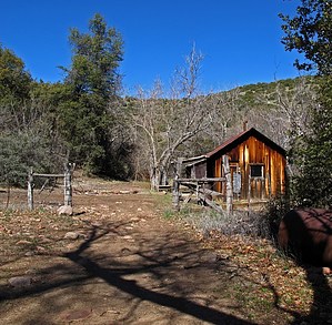
..Two TRIPS in One.. by Grasshopper   Overview OverviewI can't decide what would be more rewarding- an exploratory "off-road day trip" to visit this most scenic, historic, and remote Salome Wilderness upper Thompson Mesa Watershed area and old 1890's Boyer Ranch Cabin Complex, "or" a most scenic, diverse, remote, & challenging "day hike" on the 6.25mi one way Boyer Cabin TR#148(to its intersection with the Salome Wilderness- Hell's Hole TR#284). You really can't do justice to these two-day trip options by trying to do both in just one day (unless, of course, you decide to primitive camp or backpack in this area which is also recommended!). Warning #1 Either day trip option from the PHX area entails a long day outing (~4hr drive one way) with prior planning and the correct high-clearance vehicles to reach this remote upper Thompson Mesa Watershed area(at 4600'+) and continuing on a steep downhill via 4x4 only to the Boyer Cabin Complex-Boyer Cabin TH/Trail#148(at 4200'). The 6.25mi one-way TR#148 hike is "very" difficult to follow in at least three different segments of this hike. Good route finding capability is required, with proper maps, and having the Default GPS ROUTE is highly recommended. Also, in the "Driving Directions Section", please note my comments regarding low wash/creek water crossings on FR60 during our AZ rainy months of the year.
Check recent triplogs and photosets for current details (particularly check ones dated 2/19/21). History Beginning around 1891(the year that local resident Joseph Boyer registered his official cattle brand in Globe, AZ), the Boyer Cabin Complex became the site of a large working ranch. The isolated location of this ranch, below Thompson Mesa in a canyon bottom riparian area, surrounded by huge old shade trees, and bordering the Salome Wilderness Boundary, tells us what hardy people these early ranchers were. One can almost feel their presence as you explore the well-preserved remaining cabin(with full windows/doors), bunkhouse, barn, and corral. Judging by the many antique furnishings left in place, it appears as if it may have been occupied as late as the mid-1900s. History books and archives have it that "Joseph Boyer" was present when the Graham-Tewksbury Feud began in 1886, marking the beginning of the bloody Pleasant Valley War(cattlemen vs. sheepherders). Hike The most popular way to hike into the Salome Wilderness' "Hell's Hole" area is via Hell's Hole Trail#284 accessed off Hwy#288 (the Young Hwy). The much more remote and challenging Boyer Cabin TH/Trail#148 allows you to access Hell's Hole from another side of the Salome Wilderness IF you are good at trail route finding "and" IF you give yourself enough time to do this ~16.5mi R/T hike. It would be very tough to hike it all in one day to have any extra time to enjoy and explore scenic Hell's Hole before needing to head back to the TH for the slow and long drive out. For this reason above (unless you are camping in this area or backpacking in), this hike description will concentrate only on a big enough "one day chew": just completing the entire 12.5mi R/T "in and out" hike on the much more remote and less traveled Boyer Cabin TR#148 to its intersection with Hell's Hole TR#284. This hike starts on the Jeep access road just across from the Boyer Cabin Complex where you are parked- just past the 1st open gate (see TH driving directions for details). You are now at GPS LOCATION (33degrees 49.420N -111degrees 04.057W). Start hiking down this Jeep Road, which will soon take you through a 2nd open gate, then continue down this Jeep Road and follow it as it continues into a rocky creek bed that crosses over a creek crossing ~0.33mi from where you parked. Continue following this old Jeep Road for ~1.0mi to a Jeep spur road (veering both Straight ahead uphill and also veering to the Right..easily missed!). You are now at GPS LOCATION (33degrees 50.105N -111degrees 03.593W). At this point, you want to take the spur road that veers to the Right, NOT Straight ahead uphill (if you start an uphill climb and start seeing some of those dark brown plastic F/S Wilderness Boundary/Do Not signs, then turn around and head back to find that spur road you missed). OK, now you have located the spur road that veers to the Right: ~150 yards down this Jeep spur road is the official, almost entirely faded-out and barely hanging up, old Tonto Natl Forest- Salome Wilderness wooden boundary sign (Now you are at the original TH start of The Boyer Cabin TR#184)! So, where is the trail? Look Left, and you will see a dirt embankment... hike over and up this dirt embankment, and you will be looking into a rather large human-made "animal watering pond/tank" that is part of the original Boyer Ranch. Hike around this closer end of the watering tank and start looking for sometimes almost completely hidden (in high grass) or almost completely collapsed rock cairns as you proceed hiking uphill and away from this watering tank. At this point, if you are not already doing so, I highly recommend that you start concentrating on and following our Default GPS ROUTE that, hopefully, you have loaded into your GPS. IF you don't see any obvious rock cairns to follow in this immediate area, just start heading in a NNW direction to intersect our "first" GPS Loop Route "Line" and then start following this GPS line route uphill, continually looking for old rock cairns in the high grass/rocky areas as you hike. From this point on, the secret and challenge is first to find the cairns, then follow uphill our GPS Route via our straightest line route as possible (without making any loops as we did in error trying to find the trail). After hiking a total of ~2.0mi in on your GPS, you should now be "keying-in" on our next "important" GPS LOCATION at 33.8407 -111.0482. This is where the Boyer Cabin Trail crosses at a high mesa through an OPEN GATED fence line. From this point and for the next 1.25mi, the trail and cairns are much easier to follow as you proceed across some very scenic high mesas (topping out at 5600') with scenic distant views North into the rugged Salome Canyons/Salome Creek and following the trail down and then continuing up two rugged canyon drainages with beautiful slick rock flowing creeks (as of this writing). Once you start climbing out of the second canyon drainage, for the next 1.75 miles, you gain altitude into a pine forest area with numerous downed trees and small drainages that initially follow to the left of the trail, with the trail sometimes crossing into and over these drainages. This is the 3rd difficult area to trail find. There are cairns, but you really have to concentrate in this route-finding area, or you will lose a lot of time as we did on this, our first attempt hiking in on this little-used trail. "Suggestion": again, follow our GPS ROUTE's straightest line! After you complete this section, the last 1.25mi to the Boyer Cabin Trail intersection with Hell's Hole Trail at 5475' is wide and easy to follow. Gate Policy: If a gate is closed upon arrival, leave it closed after you go through. If it is open, leave it open. Leaving a closed gate open may put cattle in danger. Closing an open gate may cut them off from water. Please be respectful, leave gates as found. The exception is signage on the gate directing you otherwise. Check out the Official Route and Triplogs. Note This is a moderately difficult hike. Leave No Trace and +Add a Triplog after your hike to support this local community. | ||||||||||||||||||||||||||||||||||||||||||||||||||||||||||||||||||||||||||||||||||||||||||||||||||||||||||||||||||||||||||||||||||||||||||||||||||||||||||||||||||||||||||||||||||||||||||||||||||||||||||||||||||||||||