Route Editor

| Guide | ♦ | 28 Triplogs | 0 Topics |
details | drive | no permit | forecast | route |
stats |
photos | triplogs | topics | location |
| 355 | 28 | 0 |
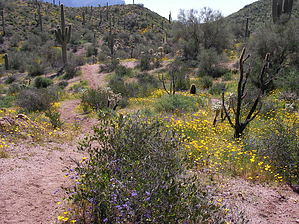
thars gold in them thar hills by OhOh7  Overview OverviewOrohai is the mining district of the southern Goldfield Mountains. This reasonably short loop hike goes right in the middle of the "gold country". Area Most are familiar with the Four Peaks Wilderness and the Superstition Wilderness, but thousands drive the Apache Trail and forget to look to the left. The Goldfield Mountains lie between Usery Pass road (the extension of Ellsworth) and the Saguaro Lake area of the Salt River. There isn't a managed trail system, but many jeep roads crisscross the area. These roads go to electric towers and various places of interest.
Almost 900,000 ounces of gold was taken from Goldfield Mountain mines from 1877 to 1959. In 1892 there were about 50 operating gold mines in the Goldfields. Some of the most famous are Mammoth, Bluebird, and Bulldog. Note that there has never been any positive proof that a gold mine ever existed in the Superstitions. One theory claims Jacob Waltz knew all about the Goldfield mines and gold. He was a crafty guy. Some say he took gold bit by bit- from a Goldfield mine. Then went across the Superstitions to the south side and then back northwest to the assay offices to value his find. He'd claim he found it in the Superstitions at the Lost Dutchman Mine. If you do a bit of research, you will find they say that a ledge of quartz and gold was found at the Lost Dutchman Mine. No proof. BUT, an exact such ledge of quartz and gold was evident at the Bulldog mine. Many say Waltz took the gold from the Bulldog and that mine is the Lost Dutchman. Whether there's any truth to that or not, I like the angle! Some years back, the Bulldog Mine entrances were completely covered over, buried under tons of earth with heavy equipment. It is just to the left of the Hackamore TH. When Waltz told many that the lost mine was in the shadow of Weaver's Needle, it shows me he had quite a sense of humor. What month, what year, and what time of day would that be???? Hike This hike loops right in the middle of the Goldfield Mountains. Which commands some attention due to the surrounding gold mines. Tailings are evident in many places. This can be anywhere from a 5 to 8-mile route depending on your choice of direction. The start is at the Hackamore TH, a left turn off the Apache Trail just before the Museum. It is named Hackamore Road and goes past a large electrical substation for about 2 miles to a blocked parking lot. On the hill to the west is the old Bulldog mine site. There is also a welcome to Apache Junction sign at the junction or 88 and Hackamore. The route we took was north on a jeep road (named Packsaddle Road) to a trail (not signed) that goes northwest until we ran into another jeep road where we turned southwest past the rock house (an old ruin with a well that no one seems to know much about) to an unmarked trail going southeast which is called the actual Orohai trail and a return to the hackamore TH. Our trip was 5 miles. Why did we take it now? How about beautiful flowers and maybe scattered gold???? Once we started the trail to the NW, when we left the road, we went up and down hills with great views of surrounding mountains and the purple, yellow, magenta, orange, and green background. The most pleasing floral display I have ever seen in Arizona. We saw no people, and the area looks untouched. Little valleys, rounded hills, sharp drainages, and a few places where one has to climb over ridges. I enjoyed this hike and will go back to that area to see more of nature's floral color display. Summary Try the Goldfield Hikes. Routes from the south side of the mountains to the Salt River are about 9 miles. There are some astounding canyons, and some present a real challenge. Just remember, this is gold country. Check out the Official Route and Triplogs. Leave No Trace and +Add a Triplog after your hike to support this local community. | ||||||||||||||||||||||||||||||||||||||||||||||||||||||||||||||||||||||||||||||||||||||||||||||||||||||||||||||||||||||||||||||||||||||||||||||||||||||||||||||||||||||||||||||||||||||||||