username
X
password
register
for free!
help
 This is likely a great time to hike this trail!  Check out "Preferred" months below, keep in mind this is an estimate. 
 

The Manitou Incline, CO

Guide 21 Triplogs  0 Topics
  4.3 of 5  
Fav
Wish
2
details
drive
no permit
forecast
route  
stats
photos
triplogs
topics
location
116 21 0
Statistics
tap row or icons for details
Difficulty 4 of 5
Route Finding 1 of 5
Distance Multi-Loop 2 miles
Trailhead Elevation 6,637 feet
Elevation Gain 1,995 feet
Accumulated Gain 1,995 feet
Avg Time Round Trip 2-3 hours
Kokopelli Seeds 11.98
 Interest Peak
 Backpack No
feature photo
Photos Viewed All MineFollowing
Will recalculate on button tap!
22  2023-12-02 Mike_W
10  2019-09-29 Stoic
5  2019-08-26 sneakySASQUATCH
4  2018-09-11 sneakySASQUATCH
6  2018-05-07 sneakySASQUATCH
6  2018-04-15 sneakySASQUATCH
17  2015-11-14 ddgrunning
14  2013-07-17
Incline Manitou Springs hunt
sneakySASQUATCH
Page 1,  2
Author
author avatar Guides 6
Routes 0
Photos 100
Trips 25 map ( 170 miles )
Age 40 Male Gender
Location Colorado Springs, CO
Associated Areas
list map done
South Central Region
Historical Weather
Trailhead Forecast
Radar Map
Expand Map
Preferred Jul, Aug, Jun, Sep → 9 AM
Seasons   ALL
Sun  5:32am - 6:24pm
Official Route & 2 Rts
 
0 Alternative


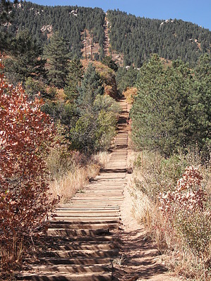
Think you can handle The Incline?!
by kentman2020

 Likely In-Season! 
History
Completed in 1907, the Manitou Incline was a 1 mile cable tram built to support the construction of a hydroelectric plant and it's waterline. After performing this service, the railway was then purchased by Dr. Brumbach and turned into a tourist attraction.


The incline boasted a 16 minute ride to "scenic splendors", 10 miles of hiking trails in Mount Manitou Park, and claimed to be the "longest and highest incline on the globe." Spencer Penrose bought the incline in 1923 and made it part of his tourist attraction empire, which is now owned by the Oklahoma Publishing Co. During this time, the cars were upgraded to allow for a retractable roof and more safety.
remove free decal offer
The summit station was again rebuilt in 1958 and lasted until it was dismantled upon closure of the incline.In 1990 the Manitou Incline closed after a rockslide damaged the tracks again and the Cog Railway decided to cease the failing operation and focus on the profitable Cog Railway. Ever since then the route has seen a steady stream of runners, joggers, hikers, walkers, and even some crawlers.

Overview
The route is short and steep, gaining nearly 2000 feet of elevation in 3/4 of a mile it is truly a Colorado workout.

Hike
The rails have been pulled up, however most of the old ties, spikes and various metal pipes and stakes remain. Hike west on the railroad bed. The trail is obvious before you as it ascends the mountain. The slope of this trail will reach 50 degrees at one point, which is why so many people use this trail for a workout. If the trail proves to be too much there is a bail-out point halfway up where the Barr trail is just across a gully from the incline trail. (Look for a brown log fence you won't miss it) You will pass one false summit before you reach the remains of the old summit station. I do not recommend hiking back down the incline trail, it's difficult and dangerous to do. Using the bail-out point halfway will make the round trip roughly 2 miles long. Going to the summit is about a mile with 4 miles down the Barr Trail back to the parking lot.

WARNING
People have been seriously injured on the spikes and various metal objects on this trail! Please Use caution when hiking!

2010-10-15 kentman2020


    Check out the Official Route and Triplogs.

    Note
    This is a moderately difficult hike.
    Leave No Trace and +Add a Triplog after your hike to support this local community.
    WARNING! Hiking and outdoor related sports can be dangerous. Be responsible and prepare for the trip. Study the area you are entering and plan accordingly. Dress for the current and unexpected weather changes. Take plenty of water. Never go alone. Make an itinerary with your plan(s), route(s), destination(s) and expected return time. Give your itinerary to trusted family and/or friends.

     Permit $$
    None


     Directions
    or
     Road
    Paved - Car Okay

    To hike
    Take highway 24 west from Colorado Springs and take the Business 24 through Manitou Springs. Near the center of historic Manitou Springs you will come to a round-a-bout (rotary) where you can turn onto Ruxton Avenue. Take Ruxton southwest towards the Cog Railway. On days that parking is not too busy you can go to the Barr Trail parking lot just beyond the cog railway parking. Look for a right turn after the Manitou powerstation. This parking lot frequently fills up. If it is full, DO NOT park in the Cog Railway parking. They will tow you. If that lot is full it's best to head back down to Ruxton and find parking on the side of the road there. Be sure to park legally, lots of tickets get issued to illegally parked cars here.
    page created by kentman2020 on Oct 14 2010 4:39 pm
     90+° 8am - 6pm kills
    helpcorrectionissue

    end of page marker