 Route Editor

| Guide | ♦ | 13 Triplogs | 0 Topics |
details | drive | no permit | forecast | route |
stats |
photos | triplogs | topics | location |
| 55 | 13 | 0 |
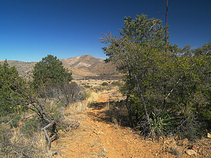
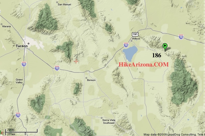
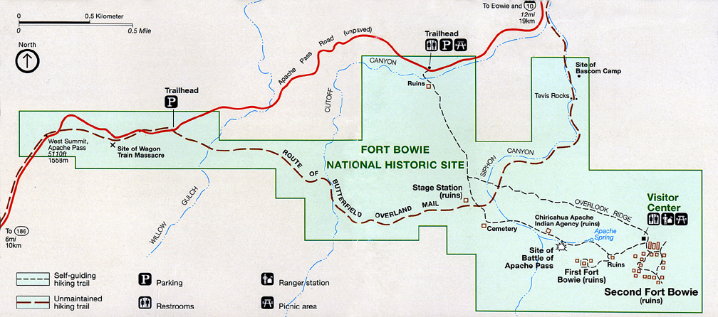
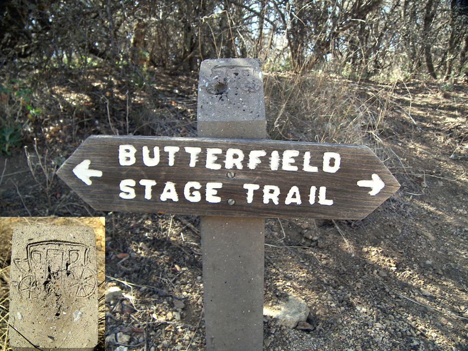
wild west war zone by PrestonSands   Overview OverviewThis hike follows the route of the historic Butterfield Trail, through the Fort Bowie National Historic Site. This is a peaceful and relatively easy hike through a historically violent area, where Apaches fought the U.S. Army and white settlers to retain control of their homeland. The National Park Service only maintains the middle portion of the trail in the park, but the entire route is well marked. Small brown posts with a wagon engraving on top, located every hundred yards or so, mark the location of the Butterfield Trail. This trail can be hiked in its entirety, or, for those looking for something less adventurous, the middle portion of the trail makes a nice hike in itself, and also provides an alternate route to the ruins of Fort Bowie.
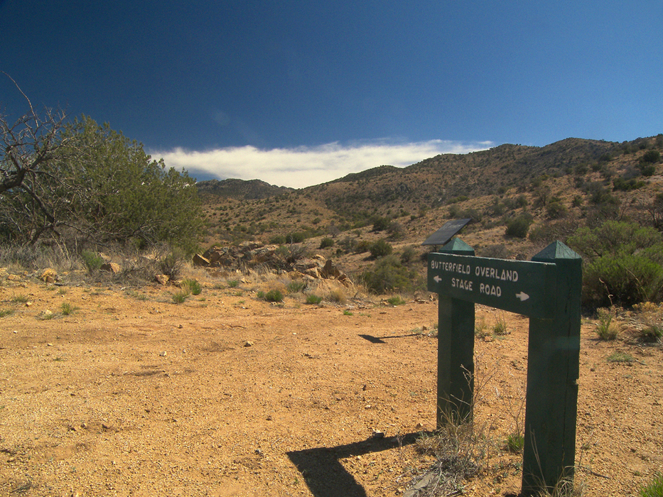
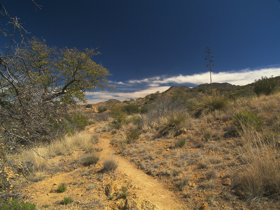
In 1857, Congress authorized the establishment of an interstate mail route between St. Louis and San Francisco, to help alleviate California's isolation from the rest of the United States. A southern route was chosen, to avoid interference from winter snows. John Butterfield was awarded the contract to build and operate the mail trail. After a year of hard work, and with John Butterfield's words "...nothing on God's earth must stop the United States mail" as inspiration, stagecoach drivers began their runs in September 1858. The Arizona portion passed through Apache Pass to take advantage of perennial Apache Spring, and a stage station, one of nineteen in Arizona, was built nearby. Apache Pass was the highest and most dangerous point on the entire 2,800-mile trail, due to strained relations with the indigenous Chiricahua Apaches. All remained peaceful though, until February 1861, when warfare broke out between the Americans and the Chiricahua Apaches, as a result of Cochise being wrongly accused of kidnapping and livestock thievery, in what became known as the "Bascom Affair". As a result of the Bascom Affair and the government's fear that the newly formed Confederate States Of America may interfere with the mail service, the Butterfield Overland Mail was discontinued in March of 1861. Hike The western end of the trail, which is about 0.6 miles long, from Apache Pass to just east of the wagon train massacre site, is a bushwhack, that parallels and repeatedly crosses the Apache Pass Road, so I won't describe it here. It is not included in the mileage listed under the hike's statistics. The parking area (GPS location 32.15251 N, 109.47203 W) on the south side of the road, 0.6 miles east of Apache Pass, makes a good spot to start your hike. For this description, this will be milepost 0.0. A green sign identifies the "Butterfield Overland Stage Road" (Butterfield Trail), which drops down the hillside from the parking area, and heads for the hills to the east. The trail rolls over low ridges and shallow washes, through open chaparral country, typical of southern Arizona. It is well defined and maintained, with the brown signposts marking the way. Breaks in the hills provide a peek or two of the broad San Simon Valley to the east, while the peaks of the Dos Cabezas range keep watch to the north. The Butterfield Trail arrives at a saddle at the one-mile point, where you will get your first view of Fort Bowie. The trail now begins a steady descent to the grassy valley below Apache Spring, where it crosses the main trail to Fort Bowie, at 1.5 miles, near the ruins of the stage station. If you haven't been to the ruins at Fort Bowie, consider taking a 2-mile round trip side hike along the Fort Bowie Loop (see Fort Bowie Loop hike description). Continuing, the Butterfield Trail now crosses the two branches of the Fort Bowie Loop and becomes a primitive and unmaintained (but still marked) trail. It begins to follow the sandy bottom of Siphon Canyon, into the dark gray limestone hills. The trail frequently crosses the wash, but always stays near it, so getting off route is not an issue. At the 2 mile point, the Butterfield Trail exits the wash along the south bank and shares its route with one of the park's 4wd access roads for a short distance. A large cottonwood and some sort of box-covered spring are found here. The trail continues east through a shady patch of hackberry trees, before turning north with the canyon. At 2.3 miles, the trail passes below the "Tevis Rocks", where there is a sign next to the wash, listing the park regulations. At this point, the wash splits. Take the left (west) branch, where the Butterfield Trail will reappear, about 300 feet downstream of the sign. Somewhere in the vicinity of the Tevis Rocks is where Lieutenant Bascom and 54 of his soldiers camped in 1861, on the ill-fated mission to locate and capture Cochise. The Butterfield Trail will reach the park boundary at 2.6 miles, which is marked by a barbed-wire fence and a locked green gate across the wash. The Butterfield Trail is about 100 feet east and slightly above the wash at this point. The brown signposts cease, and there is no trace of the trail beyond the fence, where it crosses onto B.L.M. land. The Apache Pass Road is visible on the hillside at the mouth of the canyon. At this point, you can return the way you came, or you can continue another 0.75 miles to the main Fort Bowie trailhead, by crossing the fence, and heading down Siphon Canyon to the Apache Pass Road, then turning left to follow it. Gate Policy: If a gate is closed upon arrival, leave it closed after you go through. If it is open, leave it open. Leaving a closed gate open may put cattle in danger. Closing an open gate may cut them off from water. Please be respectful, leave gates as found. The exception is signage on the gate directing you otherwise.
Check out the Official Route and Triplogs. Leave No Trace and +Add a Triplog after your hike to support this local community. | |||||||||||||||||||||||||||||||||||||||||||||||||||||||||||||||||||||||||||||||||||||||||||


