Route Editor

| Guide | ♦ | 9 Triplogs | 0 Topics |
details | drive | permit | forecast | 🔥 route |
stats |
photos | triplogs | topics | location |
| 93 | 9 | 0 |
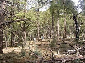
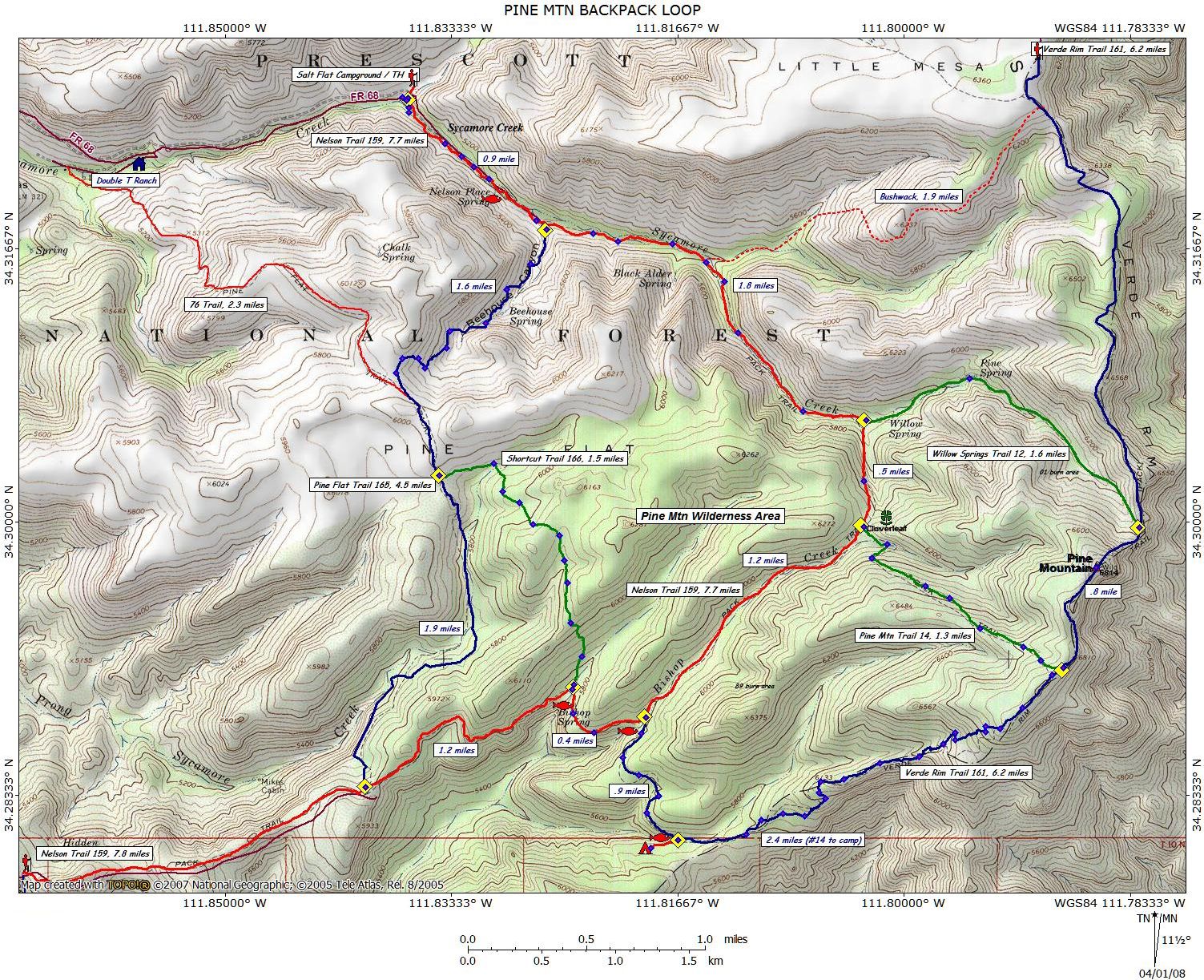
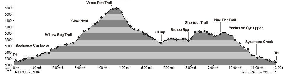
Shorcut into the wilderness! by Moovyoaz   Pine Mountain is one of Arizona's lesser-known wilderness areas, offering fine hiking without the crowds. It offers superb views of the Mazatzal Wilderness and the wild Verde River country south of Camp Verde. I did this hike with a group of dayhikers and backpackers from the Friends Hiking Club. The dayhikers basically did the Pine Mtn Verde Rim Loop. The backpackers did an interesting variation as described below. Pine Mountain is one of Arizona's lesser-known wilderness areas, offering fine hiking without the crowds. It offers superb views of the Mazatzal Wilderness and the wild Verde River country south of Camp Verde. I did this hike with a group of dayhikers and backpackers from the Friends Hiking Club. The dayhikers basically did the Pine Mtn Verde Rim Loop. The backpackers did an interesting variation as described below.Hike: We started south-east on the Nelson Trail #159 along Sycamore Creek past Nelson Place Spring, the site of an old homestead and ranch. As an Arizona native, I must say the trail along Nelson Spring is among the most beautiful I know, passing through an oak riparian area with clover and other greenery. The creek was flowing from the springs along the trail, along with the snowmelt we were to encounter later. After 0.9 miles, we passed the Pine Flat Trail #165 lower trailhead (sometimes incorrectly shown as the Beehouse Canyon Trail), which follows its namesake canyon north past Beehouse Spring and up to a saddle at Pine Flat.
After returning south to the Verde Rim Trail #161 junction, our two groups diverged; the dayhikers returned the way they came to the starting trailhead at the Salt Flat Campground. The backpackers followed the Verde Rim Trail #161 to the southwest. This description continues here, where things very got interesting. After a short distance, the Verde Rim Trail #161 drops 1000' off the edge of the Verde rim. Here the terrain traverses through mixed pines and oaks and soon turns into thickets of manzanita. Note the trail becomes faint here, so be sure to watch for the cairns that mark the way down the slope. After 2.4 miles from the trail #14 junction, trail #161 turns to the west and re-enters the pines where it crosses a creek that, on March 07 and 08, had pools of water (7.2 miles). Here is the first best-kept secret of the Pine Mtn Wilderness. Continuing off-trail to the west about 100 yards, we found an excellent camp area that's all you can ask for; a small protected valley among the pines along a creek with water. There's even a nice fire ring and plenty of firewood available. In this 1 acre park we spent a pleasant night under a full moon (34.2801, -111.81867). The following morning we arose to a fine, clear day to continue our trek back to our cars. We backtracked the short distance to the Verde Rim Trail #161, crossed the creek, then headed west. After 0.9 miles trail #161 ends at the upper junction of the Nelson Trail #159, which is followed 0.4 miles west to Bishop Springs (8.5 miles). Here is the second best-kept secret of the Pine Mtn Wilderness. Our original plan was to continue west along the exposed edge of the wilderness on trail #159 to the Pine Flat Trail #165, and north down Beehouse Canyon. But during a prior pre-hike, I came across the 'Shortcut Trail' #166 (34.29009, -111.82434). Normally I'm skeptical of any trail named 'Shortcut', believing that's how the Dutchman got lost! Although not listed on most topo maps, the map posted at the trailhead shows #166 turning sharply to the north and then west up through the pines for 1.5 miles, connecting back with the Pine Flat Trail #165, cutting about 1.6 miles off the return trip. Just be sure to follow the cairns to the northwest. Once back on trail #165 (10 miles), we continued our return north, down the rocky yet scenic Beehouse Canyon to the Nelson Trail #159 (11.6 miles), then north-west 0.9 miles to our trucks at the Salt Flat Campground (12.5 miles). All in all, a fine ending to an adventurous weekend!
Check out the Official Route and Triplogs. Leave No Trace and +Add a Triplog after your hike to support this local community. | ||||||||||||||||||||||||||||||||||||||||||||||||||||||||||||||||||||||||||||||||||||||||||||||||||||||