|
| | | |
| |
|
| Backpack | 11.00 Miles |
200 AEG |
| | Backpack | 11.00 Miles | 3 Days | | |
| 200 ft AEG | | 35 LBS Pack | | |
|
|
| |
| Linked |
|
none
[ show ]
| no linked trail guides |
| Partners |
|
none
[ show ]
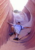
| no partners | | Starting from the east trail-head, we did our annual post-Thanksgiving Friends Backpack in Aravaipa. It was 5-6 degrees warmer than previous years, and we had to travel almost to the spring in Deer Canyon for water to appear. Nice fall colors though.
On Saturday we hiked up Parsons Canyon past the remains of an old cabin and a spring. On the way back about ½ mile from base camp at Deer Canyon we came up on 4-5 deer. As we stopped to take pictures, we heard rocks falling to our right.
About ½ way up 30-35 coatis were scrambling up the rock face like ants, or attempting to. As we snapped pictures, 1 fell 30 feet into the brush with a loud thump. In a second he was scrambling up again. Two more fell, and quickly started over. As the pack climbed, they kept looking back, cussing us I'm sure all the way. This went on for several minutes until the pack made it up to a crack in the wall or a ledge. Meanwhile the deer were watching us and the mad rush unconcerned, as if to say 'What's their problem?'. As we walked by within 15 feet, they would raise their head for a peek, then go to back to grazing. For the coodegrass, shortly past the deer on the left there was a big horn 300 feet above watching the commotion below.
I thought out-loud, 'Deer, flying monkeys, big horn. What's next? Bigfoot?' No, only the resident blue heron and several javelina on Sunday's trip out. I've seen these Aravaipa wildlife on previous trips, but so many in less than 10 minutes was pretty amazing. I'll post pictures when time allows. |
|
Autumn Foliage Observation Moderate
Normal fall colors, perhaps delayed a bit |
|
| _____________________
| A drunkard's dream if I ever did see one |
| | |
|
|
|
 Route Editor