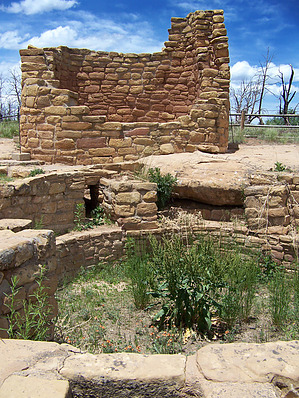
Tower/kiva complexes exist through the greater southwest, but are primarily focused around the Mesa Verde/Montezuma Valley/Great Sage Plain areas. Their exact purpose is unknown, with ideas ranging between ceremonial towers where priests could ascend from the connected kivas, to the secular lookout/signal tower hypothesis, where the Anasazi could pass messages over great distances very rapidly. Their true purpose remains unknown today, but one thing is for certain; they are fascinating to observe, and Cedar Tree Tower is one of the best preserved examples of such construction that is open to the public. It is also very easy to access, as it is located right next to the parking area.
After you have seen the tower and kiva it is informative to take a hike along the Farming Terrace Trail. While up at the Far View Complex a checkdam and artificial lake were on display, here at the Farming Terrace, you can get a much better idea of how these ancient people farmed their food on such a high, rugged, and dry landscape. Even though you are at almost 7100 feet, the primary vegetation type is still pinon-juniper woodlands. Usually the transition to Ponderosa-dominated forests happens around 7000 feet above sea level. From the Mesa Verde NPS: Adjacent to the Cedar Tree Tower area is the trailhead for the Farming Terrace Trail. This 1/2 mile loop trail provides an opportunity for a leisurely hike. Along the trail there are good examples of Ancestral Puebloan check dams and farming terraces.
Terracing was a common strategy used by the people of Mesa Verde. Check dams were built along sloping, narrow drainages, creating the terraced effect. The dams slowed water runoff from rainfall or melting snow. As the water slowly ran down the drainage, soil would be captured behind each dam. These pockets of soil retained moisture and became perfect places for planting. The Farming Terrace Trail helps you to discover how farming was accomplished at Mesa Verde 800 years ago.
Seeing these ancient terraces still capturing water and enriching the soil is a pretty neat thing, and it can give you a real sense of connection to the past. Once you are done viewing these ancient farmlands, return to your vehicle by the tower, and continue your tour of Mesa Verde.
WARNING! Hiking and outdoor related sports can be dangerous. Be responsible and prepare for the trip. Study the area you are entering and plan accordingly. Dress for the current and unexpected weather changes. Take plenty of water. Never go alone. Make an itinerary with your plan(s), route(s), destination(s) and expected return time. Give your itinerary to trusted family and/or friends.
Permit $$
NPS
Mesa Verde National Park $10-15 per vehicle (depends on season) good for 7 days Permit Information
Directions
Road
Paved - Car Okay
To hike From Cortez, Colorado, take US160 east to the signed exit for Mesa Verde National Park. Pay the entrance fee and proceed up the winding road leading to the top of the mesa. Past the Far View Visitor's Center, head south on the main Ruin's Road. You will pass the Far View complex on the left, then several miles later you will pass some employee housing on the right. On the left will be a series of water tanks. The road is signed for Cedar Tree Tower, and it heads east from the main road just to the south of the water tanks. Park in the parking area and begin your hike there.
 Route Editor