 Route Editor

| Guide | ♦ | 4 Triplogs | 0 Topics |
details | drive | permit | forecast | route |
stats |
photos | triplogs | topics | location |
| 75 | 4 | 0 |
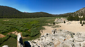
An intersection of rivers by chumley For the purposes of getting to Tunnel Meadow, the statistics shown and trail as described begins in Mulkey Meadow south of Trail Peak, where hikers can arrive from the north via Horseshoe Meadow over Trail Pass or Mulkey Pass (connecting to the PCT), or from the south via a trail from Ramshaw Meadows. It ends about 7 miles later at the historic Tunnel Forest Service Station, where trails lead in four separate directions.
The next 1.25 miles follows a sandy path on the northern flank of the meadow. When the meadow ends, the trail follows the higher ground above the SFK drainage. You'll pass a signed junction for a trail that heads north to Big Whitney Meadow, Rocky Basin Lakes, Siberian and Cottonwood Passes. Just past that junction the trail makes a short traverse across the location of the historic tunnel and reaches a cabin, 30-foot redwood water tank (last used in 1978) and other remains of the Tunnel Forest Service Station. Trails here lead south to Kern Peak, southwest to Volcano Meadow, Little Whitney Meadow, and the main stem of the Kern River (9 miles and 2,500 feet lower). To the southeast, a trail leads along the South Fork Kern River to reach points such as Casa Vieja, Indian Head, Casa White Sands, and the Monache Ranger Station. History: Golden Trout Creek and South Fork Kern River were connected at some point in geologic history. One was a tributary of the other, and they merged near what is now the Tunnel FS Station. A volcanic event that I haven't been able to date divided the two rivers, which are now separated by a lava flow and ridge of sediment just 300 feet across. Both streams now empty into the mainstem of the Kern River, though despite being just 100 yards from each other near Tunnel Meadow, SFK flows 88 miles and Golden Trout about 75 miles before the two join again at Lake Isabella, a manmade reservoir on the Kern River 50 air miles south of Tunnel Meadow. Despite the geologic separation, Chinese laborers were contracted to build a tunnel between the two streams in 1886, diverting most of the water from the stronger-flowing Golden Trout Creek into the South Fork Kern River. Unsurprisingly, this upset ranchers in the Golden Trout drainage and rumor has it that the tunnel either collapsed on its own or was blown up shortly after being constructed. Knowing this history, it is easy to see the location and remnants of the tunnel as you hike past its location today. Tunnel Meadow itself has an interesting history. An 1,800 foot airstrip was constructed in 1931 so a wealthy cattleman could fly there for the purpose of fishing! Over the years, an air camp was established with tents, an office, outhouses, and a corral where pack animals could be rented for travel elsewhere on the Kern Plateau. By the 1950s, Tunnel Aircamp was a popular spot for general aviation pilots, and regarded as one of the most challenging fields to land. At over 9,000 feet elevation, some sources indicate it was the highest elevation airfield in the US at the time. Winds and terrain difficulties caused frequent crashes. By 1970, the Bob White Flying Service outfitted tourists and their gear, flying them 20 minutes from Lone Pine to Tunnel Aircamp for $35. The camp rented tents, beds, linens, and all other essentials for a mountain getaway! The FAA required airfields to have telephone service, so the aircamp featured a single-wire old crank-style telephone connection between camp and several ranger stations on the plateau, connecting all the way to Lone Pine. In 1978, with the establishment of the Golden Trout Wilderness the airport was closed to general aviation. However the aircamp remained open and outfitter flights continued under an annually renewed special use permit until it expired 12/31/1982. Today, few signs of the aircamp remain. Just the old corral and some remnants of buildings that once stood at the site. The landing strip is still somewhat visible on satellite photos and a keen observer can find it when hiking in the meadow. The old crank telephone wire has been broken in many places from fallen trees, but hikers will encounter it often on the trails across the Kern plateau. Check out the Official Route and Triplogs. Leave No Trace and +Add a Triplog after your hike to support this local community. One-Way Notice This hike is listed as One-Way. When hiking several trails on a single "hike", log it with a generic name that describes the hike. Then link the trails traveled, check out the example. | |||||||||||||||||||||||||||||||||||||||||||||||||||||||||||||||||||||||||||||||||||||||||||||||||||


