 Route Editor

| Guide | ♦ | 2 Triplogs | 0 Topics |
details | drive | no permit | forecast | map |
stats |
photos | triplogs | topics | location |
| 32 | 2 | 0 |
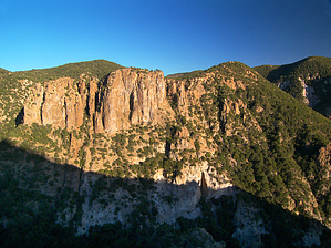
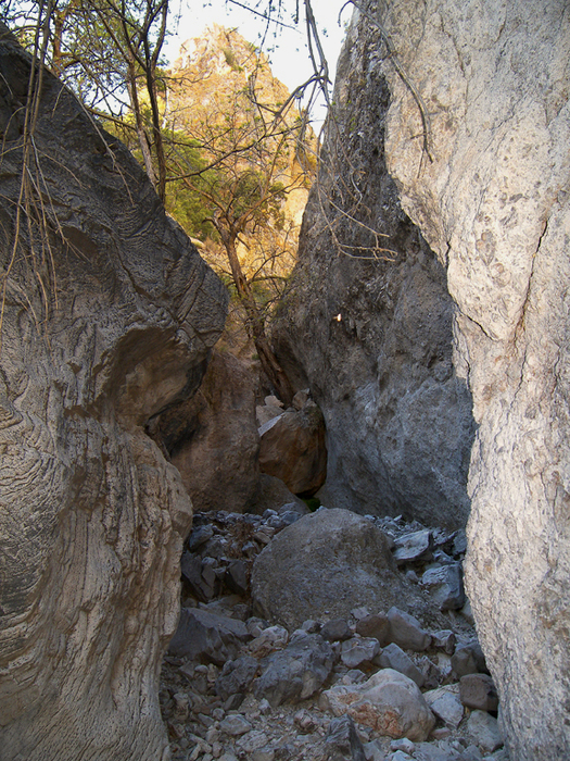
The Hand that rocks the canyon by PrestonSands   Overview OverviewThis is an off-trail hike up scenic Black Jack Canyon, in the Big Lue Mountains, along the Arizona-New Mexico border. Highlights of this hike are Black Jack Canyon's spectacular rock formations, sheer canyon walls, and a historic cave. There is also the option for canyoneering in the super-rugged, upper box area. Although this hike shares the canyon with state highway 78, traffic is light, and noise from it is rarely noticeable. Black Jack Creek appears to be seasonal, but Dunigan Spring may have year-round water. Warning The upper box is not somewhere you want to be if flash flooding is a possibility. Options for exiting the upper box area are extremely limited, due to the exceptionally rugged topography.
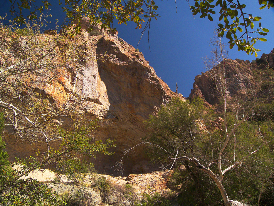
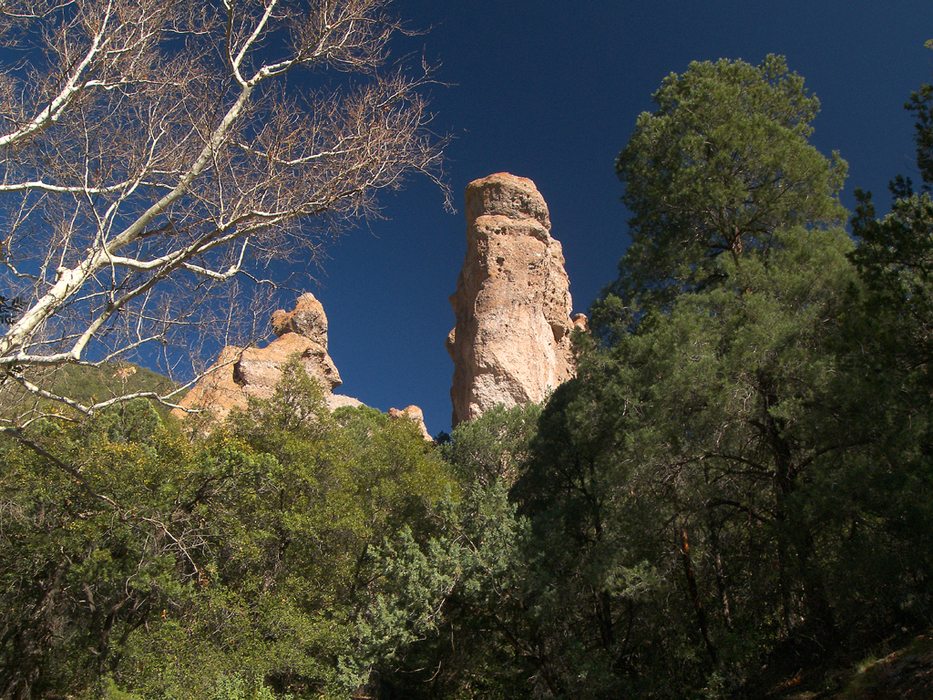
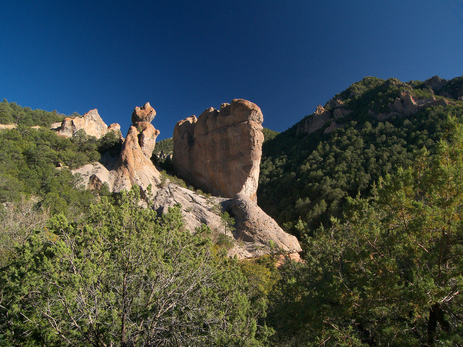
Where Arizona highway 78 crosses the forest boundary at milepost 165.1, there is a pull-out area along the south side of the highway. This is about a tenth of a mile before the Apache National Forest sign. You will need to cross through three closely spaced barbed wire gates, and then head southeast from the pull-out area, toward Black Jack Canyon. One-tenth of a mile from the highway, a shallow side ravine provides a relatively catclaw-free descent to the bottom of Black Jack Canyon. Once at the bottom, there is a well-trodden cow path that heads up Black Jack Canyon, along a narrow, grassy shelf, on the north bank of the creek. At 0.45 miles, the path arrives at a small flat above the creek, near the location of Black Jack Spring. There are some old rock walls in this area. Beyond this point, the path continues up canyon along the north bank. The local cattle have done a fine job blazing a trail through the copious catclaw. At about 0.6 miles, the path leads through another small flat, which is well shaded by evergreen oaks. At the edge of the flat, the path drops into the creek bed and disappears. Keep going upstream, and in another 0.1 miles, you will arrive at a small side canyon on the left, where Dunigan Spring flows out of the bank. At this point, the old trail reappears, and travels up the side canyon for a few hundred yards, before arriving back at Black Jack Creek again, having bypassed a short, (yet hike-able) slick rock section. Once you are back in Black Jack Creek, you will pass by the site of Black Jack Cave (33.04158 N, 109.10792 W), located at the base of the south canyon wall (see Black Jack Cave hike description for info and history). The cave (an alcove, actually) is only a couple of hundred feet from the creek and is an interesting place to visit. Just past the cave, the canyon enters a box, where a definite trail emerges from the creek bed and travels along the south bank. Cliffs of bizarrely sculpted volcanic breccia crowd the edges of the shady creek bottom. At the east end of the box, the canyon turns northeast, and passes another large alcove. Leaving the box canyon and the last bit of "trail" behind, the hike now continues up the creek bed for the next mile, through oak woodlands and below canyon walls that seem to grow ever higher. Black Jack's unusual rock formations adorn the sides of the canyon. The boulder-covered creek bottom is wide and easy to follow for the most part. The 5500-foot contour finds the creek bed passing through a narrow red rock canyon, while a giant rock column lurks in the distance. The creek soon passes near this enormous rock, which I refer to as "The Hand". Its hand shape becomes more apparent as you continue up the canyon. Black Jack Canyon soon narrows considerably, as it enters a super rugged, upper box. Seven hundred-foot vertical canyon walls and dense tree cover create a dark and mysterious atmosphere. Giant boulders occasionally wedged between the canyon walls, attempt to stop your upward progress. Finally, one-third of a mile up canyon from "The Hand", a massive chockstone, jammed into a slot canyon-like stretch, effectively blocks the canyon bottom. This is the turnaround point for casual hikers. A round trip hike to this point and back is about 5.2 miles. Adventurous souls with canyoneering skills (and rope) can continue to enjoy another 0.7 miles of hellishly rough canyon. One-quarter of a mile further up Black Jack Canyon from the chockstone lies a good-sized seasonal waterfall, where the canyon turns south. Just above it, near the rim of the canyon, lies Blackjack Campground, which sits in a wide saddle next to highway 78. Access between the waterfall area and the campground might be possible, but it looked like a very bad idea to me, so I chose not to explore that option. Have fun, and be safe. Gate Policy: If a gate is closed upon arrival, leave it closed after you go through. If it is open, leave it open. Leaving a closed gate open may put cattle in danger. Closing an open gate may cut them off from water. Please be respectful, leave gates as found. The exception is signage on the gate directing you otherwise. Check out the Triplogs. Leave No Trace and +Add a Triplog after your hike to support this local community. | ||||||||||||||||||||||||||||||||||||||||||||||||||||||||||||||||||||||||||||||||||||||


