 Route Editor

| Guide | ♦ | 61 Triplogs | 0 Topics |
details | drive | no permit | forecast | 🔥 route |
stats |
photos | triplogs | topics | location |
| 749 | 61 | 0 |
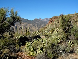
'Tweener Wilderness Hike by DarthStiller  This hike is situated just outside the Four Peaks and Superstition Wilderness Areas and a few miles west of the Salome Wilderness Area. You can see great views of all three and Roosevelt Lake and Dam throughout. This is also a segment of the Arizona Trail, picking up from SR188 and taking you to the edge of the Four Peaks Wilderness, where the Four Peaks Trail #130 then picks up the AZT. This hike is situated just outside the Four Peaks and Superstition Wilderness Areas and a few miles west of the Salome Wilderness Area. You can see great views of all three and Roosevelt Lake and Dam throughout. This is also a segment of the Arizona Trail, picking up from SR188 and taking you to the edge of the Four Peaks Wilderness, where the Four Peaks Trail #130 then picks up the AZT.Start right at the bridge adjacent to Roosevelt Dam. Park just north of the bridge in the large pullout area and look across the road for the blue Junction 88 sign. Right behind that is a wooden trail marker saying Vineyard Trail #131. At only about 0.1 miles in, there is a plaque and information commemorating Camp O'Rourke, where the workers lived who built Roosevelt Dam in the early 1900s. Look across the drainage that you immediately cross, and you can see the remains of some of the structures.
At 2.8 miles, you will encounter a lava flow that the trail goes right through, making for some unsteady footing. To your left (south), there is a fantastic view of a canyon full of saguaros that drops precipitously down to the Salt River. You can make out some mountains in the Superstitions if you're familiar enough with that area. SR88 is also very prominent. After the lava flow, the trail crosses a valley and meets FR336. Make a left onto this road and follow it for about 0.15 miles to where the Vineyard Trail picks up again. This junction is well marked and seems to be where the road ends, although mapping shows it goes further to the south. From there, the trail follows ridgelines of the area on its way up to the Mills Ridge TH, where it ends. Steep sections are interspersed between the level sections. Each steep section seems to get just a little harder as you near the end of the trail. From Mills Ridge, you can start to follow the Four Peaks Trail #130 all the way to the Lone Pine TH (on another hike, maybe). Check out the Official Route and Triplogs. Leave No Trace and +Add a Triplog after your hike to support this local community. One-Way Notice This hike is listed as One-Way. When hiking several trails on a single "hike", log it with a generic name that describes the hike. Then link the trails traveled, check out the example. | ||||||||||||||||||||||||||||||||||||||||||||||||||||||||||||||||||||||||||||||||||||||||||||||||||||||||||||||||||||||||||||||||||||||||||||||||||||||||||||||||||||||||||||||||||||||||||||||||||


